LAKEVIEW
LAKE CO (LKV)(KLKV) 3 SW UTC–8(–7DT) N42°09.67′ W120°23.95′ 4734 B NOTAM FILE LKV

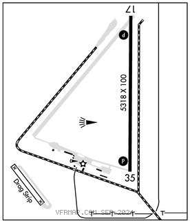
RWY 17–35: H5318X100 (ASPH) S–74, D–86 MIRL
RWY 17: REIL. PAPI(P4R)–GA 3.0° TCH 45′.
RWY 35: REIL. PAPI(P4L)–GA 3.0° TCH 45′.
SERVICE: S4 FUEL 100LL, JET A LGT ACTIVATE MIRL Rwy 17–35; PAPI Rwy 17 and Rwy 35; REIL Rwy 17 and Rwy 35–CTAF. Tetrahedron lighting inop.
AIRPORT REMARKS: Attended Apr–Sep 1700–0000Z‡, Oct–Mar 1500–0100Z‡. Flocks of large waterfowl in vcnty Nov–May. Wildlife on and invof arpt. Extv airtanker ops in fire season. Possible glider ops on twy. Drag strip oriented NW–SE lctd 3000′ southwest of Rwy 35. Twy NE–SW used for strong cross wind ldg. Cold temperature airport. Altitude correction required at or below –26C.
AIRPORT MANAGER: 541-947-4222
WEATHER DATA SOURCES: AWOS–3PT 135.525 (541) 947–5069.
COMMUNICATIONS: CTAF/UNICOM 122.8
RCO 122.3 (MC MINNVILLE RADIO)
®SEATTLE CENTER APP/DEP CON 127.6
CLEARANCE DELIVERY PHONE: For CD if una to ctc on FSS freq, ctc Seattle ARTCC at 253-351-3694.
RADIO AIDS TO NAVIGATION: NOTAM FILE LKV.
LAKEVIEW (H) (H) VORTACW 112.0 LKV Chan 57 N42°29.57′ W120°30.43′ 147° 20.5 NM to fld. 7465/19E.