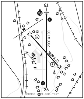
JEFFERSONVILLE
CLARK RGNL (JVY)(KJVY) 5 N UTC–5( 4DT) N38°22.00′ W85°44.29′ 478 B TPA–1278(800) NOTAM FILE HUF

RWY 18–36: H7000X100 (ASPH–GRVD) S–45, D–60 MIRL
RWY 18: MALSR. PAPI(P4L)–GA 3.0° TCH 50′. P–line.
RWY 36: REIL. PAPI(P4L)–GA 3.0° TCH 40′.
RWY 14–32: H3899X75 (ASPH) S–12 MIRL
RWY 14: REIL. PAPI(P2L)–GA 3.9° TCH 34′.
RWY 32: REIL. PAPI(P2L)–GA 3.9° TCH 32′.
SERVICE: S4 FUEL 100LL, JET A OX1, 3 LGT ACTIVATE MALSR Rwy 18; REIL Rwy 36; PAPI Rwy 18 & Rwy 36–CTAF. MIRL Rwy 18–36 opr dusk–dawn. Rwy 14–32 lgts PPR – 812–987–2841.
AIRPORT REMARKS: Attended 1100–0400Z‡. Student act & wildlife on & invof arpt. Emerg phone lctd N side of auth bldg–CTAF to open. Lndg fee for non base acft.
AIRPORT MANAGER: 812-246-7460
WEATHER DATA SOURCES: AWOS–3 118.575 (812) 246–1278. SAWRS.
COMMUNICATIONS: CTAF/UNICOM 122.7
®LOUISVILLE APP/DEP CON 132.075
CLNC DEL 118.05
CLEARANCE DELIVERY PHONE: For CD ctc Louisville Apch at 502-375-7499
RADIO AIDS TO NAVIGATION: NOTAM FILE HUF.
CATCH NDB (LOMW) 331 JV N38°28.44′ W85°44.23′ 182° 6.4 NM to fld. 528/2W.
ILS 111.7 I–JVY Rwy 18. Class IT. LOM CATCH NDB. Glideslope unusable for autopilot cpd apchs blw 1,300′.