GULF SHORES INTL/JACK EDWARDS FLD (JKA)(KJKA) 2 N UTC–6(–5DT) N30°17.38′
W87°40.31′ 17 B LRA ARFF Index–See Remarks NOTAM FILE ANB

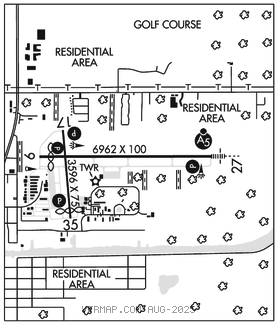
RWY 09–27: H6962X100 (ASPH–GRVD) S–80, D–100 PCN 30 F/B/X/T HIRL
RWY 09: PAPI(P4L)–GA 3.0° TCH 50′. Thld dsplcd 462′. Trees.
RWY 27: MALSR. PAPI(P4L)–GA 3.0° TCH 50′.
RWY 17–35: H3596X75 (ASPH) S–80, D–100 PCN 23 F/B/X/T MIRL
RWY 17: PAPI(P2L)–GA 3.63° TCH 48′. Trees.
RWY 35: PAPI(P2L)–GA 4.0° TCH 29′. Thld dsplcd 320′. Tree.
RUNWAY DECLARED DISTANCE INFORMATION
RWY 09: TORA–6962 TODA–6962 ASDA–6962 LDA–6500
RWY 17: TORA–3276 TODA–3276 ASDA–3276 LDA–3276
RWY 27: TORA–6500 TODA–6500 ASDA–6500 LDA–6500
RWY 35: TORA–3596 TODA–3596 ASDA–3596 LDA–3276
SERVICE: S4 FUEL 100LL, JET A+ OX 1, 3 LGT When ATCT clsd actvt MALSR Rwy 27; PAPI Rwys 09, 27, 17 and 35; HIRL Rwy 09–27; MIRL Rwy 17–35–CTAF.
AIRPORT REMARKS: Attended 1200–0400Z‡. Aft hrs svc call 251–968–5200. Extv banner towing, helicopters and para–sail ops along coastline 15 NM miles west to 20 NM east of Gulf Shores/Orange Beach, and 15 NM WSW to 20 NM ESE of JKA. HOP at or blw 300′ MSL wi 1 NM of JKA when lndg/dep helipad lctd 1.6 NM E, directly under Rwy 27 final. NOLF Barin lctd 6 miles NE of AP may be mistaken for Jack Edwards Ntl AP. Hi vol of mil tfc will be oprg in the Barin Field tfc pat from sfc to 3,000′ AGL. Class I, ARFF Index A. Index B available upon request ctc arpt mgmt 850–501–5257. Rwy 17–35 not avbl for acr opns. Unsked acr opns with more than 30 pax seats should ctc amgr.
AIRPORT MANAGER: 251-967-3968
WEATHER DATA SOURCES: AWOS–3PT (251) 923–5615 LAWRS.
COMMUNICATIONS: CTAF 118.65 UNICOM 122.7 ATIS 134.525 (251) 968–7581
®PENSACOLA APP/DEP CON 120.65
GULF SHORES TOWER 118.65 (1300–0300Z‡) GND CON 121.7
CLNC DEL 121.7 124.55 (Pensacola Apch when twr clsd)
AIRSPACE: CLASS D svc 1300–0300Z‡; other times CLASS G.
RADIO AIDS TO NAVIGATION: NOTAM FILE BFM.
BROOKLEY (L) (L) VORTACW 116.35 BFM Chan 110(Y) N30°36.76′ W88°03.33′ 130° 27.7 NM to fld. 12/4E.
VOR unusable:
265°–300° byd 23 NM blo 3,000′
TACAN unusable:
265°–300° byd 23 NM blo 3,000′
ILS/DME 110.7 I–JKA Chan 44 Rwy 27.
COMM/NAV/WEATHER REMARKS: Freq 122.7 for UNICOM use only.