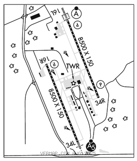
JACKSON–MEDGAR WILEY EVERS INTL (JAN)(KJAN) P (ANG) 5 E UTC–6(–5DT) N32°18.67′
W90°04.55′ 346 B LRA Class I, ARFF Index C NOTAM FILE JAN MON Airport

RWY 16L–34R: H8500X150 (ASPH–GRVD) S–120, D–221, 2S–175, 2T–585, 2D–326 PCR 605 F/C/X/T HIRL CL
RWY 16L: ALSF2. TDZL. PAPI(P4L)–GA 3.0° TCH 71′. RVR–TMR Trees. 0.3% up.
RWY 34R: REIL. PAPI(P4R)–GA 3.0° TCH 66′. RVR–TMR Trees. 0.7% down.
RWY 16R–34L: H8500X150 (ASPH–GRVD) S–120, D–250, 2S–175, 2T–585, 2D–340 PCR 816 F/D/X/T HIRL CL
RWY 16R: REIL. PAPI(P4L)–GA 3.0° TCH 80′. RVR–R 0.4% up.
RWY 34L: MALSR. TDZL. RVR–T Trees.
SERVICE: S4 FUEL 100LL, JET A, A+ OX 1, 2, 3, 4 LGT When twr clsd actvt MALSR Rwy 34L; REIL Rwy 16R and 34R; HIRL Rwy 16L–34R and 16R–34L–CTAF. Rwy 16L ALSF–2 preset on med intst exc SFL not avbl. MILITARY– JASU 8(A/M32A–86D) 3(MC–1A)
FUEL A+, A (C601–939–9366) (NC–100LL)
AIRPORTREMARKS:Attended continuously. Wt brg cpty for Rwys 16L–34R and Rwy 16R–34L are TRT–585 to accommodate C–17 acft. Be alert when xng AER 16R. Hold area 1 and 2 cmsnd on term apron btn Twy B3 and Twy B5. Ldg fee for non–coml acft over 25500 lbs; fee waived for lrgr non–sked acft with suf fuel purchase.
MILITARY REMARKS: See FLIP AP/1 supplementary arpt remark. Mil acft use Twy C7 to aces the FBO apron unless otrw drctd by ATC. CAUTION Bash Phase II period Jul–Oct. Ctc afld mgmt or Comd Post for current bird watch cond. ANG Offl bus. All tran acft 48 hr PPR. Ltd prk use. Ctc afld mgmt. Tran acft use FBO for svc. Afld mgmt opr 1300–0230Z‡ wkd, DSN 828–8372, C601–405–8372. Comd Post opr 1200–0630Z‡ wkd, DSN 828–8350, C601–405–8350. Afld mgmt and comd post have ltd comsec stor. Top secret stor unavbl. BASH Phase II in efct 1 Jul–31 Oct. Ctc twr, command post or AFM for bird haz. Wildlife most actvt +/– 1 hr of SS and SR. ARFF sts rdcd level of svc (RLS). MDT risk for mil acft Cat 4, 5, 6, 7, 8, and 9. Sev risk for mil acft Cat 10.
AIRPORT MANAGER: 601-939-5631
WEATHER DATA SOURCES: ASOS 121.05 (601) 769–1216. LLWAS.
COMMUNICATIONS: CTAF 120.9 ATIS 121.05 UNICOM 122.95
RCO 122.2 (GREENWOOD RADIO)
®APP/DEP CON 123.9 317.7 (333°–152°) 125.25 319.2 (153°–332°)(1200–0500Z‡)
®MEMPHIS CENTER APP/DEP CON 132.5 259.1 (0500–1200Z‡)
TOWER 120.9 352.0 (1200–0500Z‡) GND CON 121.7 348.6
ANG COMD POST 264.6 (172nd AW CP)
CLEARANCE DELIVERY PHONE: For CD ctc Memphis ARTCC at 901-368-8453/8449.
AIRSPACE: CLASS C svc ctc APP CON svc 1200–0500Z‡; other times CLASS E.
VOR TEST FACILITY (VOT) 111.0
RADIO AIDS TO NAVIGATION: NOTAM FILE GWO.
MAGNOLIA (VH) (H) VORTACW 113.2 MHZ Chan 79 N32°26.04′ W90°05.99′ 172° 7.5 NM to fld. 407/1W.
TACAN AZIMUTH unusable:
240°–275° byd 30 NM blo 2,000′
DME unsbl 240–275 byd 30 NM blo 2000
ILS 110.5 I–JAN Rwy 16L. Class IIIE. Unmonitored 0500–1200Z‡ Radar – See Terminal FLIP for Radar Minima.
ILS 109.3 I–FRL Rwy 34L. Class IB. Unmonitored. Localizer restricted byd 25° left and right of course.
ASR (1200–0500Z‡)