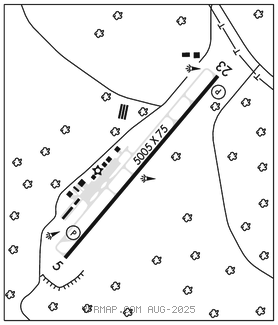
ERWIN
HARNETT RGNL JETPORT (HRJ)(KHRJ) 4 NW UTC–5(–4DT) N35°22.81′ W78°43.93′ 202 B NOTAM FILE HRJ

RWY 05–23: H5005X75 (ASPH) S–45, D–60 MIRL 0.3% up NE
RWY 05: REIL. PAPI(P2L)–GA 3.0° TCH 39′.
RWY 23: REIL. PAPI(P2L)–GA 3.0° TCH 39′. Trees.
SERVICE: S4 FUEL 100LL, JET A1+ OX 3, 4 LGT Rotg bcn obsc by trees N & W of arpt. Actvt REIL Rwy 05 & Rwy 23; MIRL Rwy 05–23–CTAF; PAPI Rwy 05 & Rwy 23 on consly.
AIRPORT REMARKS: Attended 1300–2200Z‡. Svc avbl 24/7 with prior arngmnts. GPU and bulk oil avbl. 100LL 24 hr. self svc with credit card. Rwy 05, 60 ft drop–off 350 ft fm thr & Rwy 23, 25 ft drop–off 70 ft left of cntrln. Arpt located 18 NM NE of Pope Army Airfield, low level mil act invof arpt.
AIRPORT MANAGER: 910-814-2740
WEATHER DATA SOURCES: AWOS–3 119.025 (910) 814–3946.
COMMUNICATIONS: CTAF/UNICOM 122.7
®FAYETTEVILLE APP/DEP CON 125.175
CLEARANCE DELIVERY PHONE: For CD ctc Fayetteville Apch at 910-484-8012.
RADIO AIDS TO NAVIGATION: NOTAM FILE FAY.
FAYETTEVILLE (L) (L) VORW/DME 114.85 FAY Chan 95(Y) N34°59.13′ W78°52.50′ 021° 24.7 NM to fld. 187/4W.
VOR unusable:
058°–068° blo 4,000′
090°–100°
DME unusable:
090°–100°
NDB (MHW) 417 HQT N35°25.98′ W78°40.49′ 230° 4.2 NM to fld. 298/8W. NOTAM FILE HRJ.
LOC/DME 108.35 I–HRJ Chan 20(Y) Rwy 05.