OXFORD
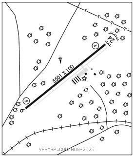
HENDERSON/OXFORD (HNZ)(KHNZ) 4 NE UTC–5(–4DT) N36°21.67′ W78°31.79′ 526 B NOTAM FILE HNZ

RWY 06–24: H5501X100 (ASPH–GRVD) S–30 MIRL 0.3% up SW
RWY 06: REIL. PAPI(P4L)–GA 3.25° TCH 43′. Trees.
RWY 24: PAPI(P4R)–GA 3.0° TCH 41′. P–line.
SERVICE: S4 FUEL 100LL, JET A1+ LGT Actvt REIL Rwy 06; MIRL Rwy 06–24–CTAF. PAPI Rwy 06 and 24 opr consly. Trees east of the arpt obscure the rotating bcn.
AIRPORT REMARKS: Attended Mon–Sat 1300–2200Z‡, Sun 1800–2200Z‡. Unattended Thanksgiving and Christmas days. Fuel 24 hr credit card svc avbl. For after hrs svc call 919–693–5769. No line of sight btn rwy ends. Rwy 06 has 30 ft drop–off 280 ft from thr & 40–60 ft drop–off 75 ft both sides of cntrln. Rwy 06 has 28 ft unmarked powerline 1000 ft fm thr on cntrln. Rwy 24 has 30 ft unmkd powerline 1000 ft fm thr on cntrln. Rwy 24 has 60 ft drop off 325 ft fm thr & 90 ft left & right fm cntrln. Hold lines are less than 150 ft from cntrln.
AIRPORT MANAGER: 919-693-5769
WEATHER DATA SOURCES: AWOS–3 118.625 (919) 693–9516.
COMMUNICATIONS: CTAF/UNICOM 122.8
®RALEIGH APP/DEP CON 132.35
CLEARANCE DELIVERY PHONE: For CD if una via GCO ctc Raleigh Apch at 919-380-3144.
RADIO AIDS TO NAVIGATION: NOTAM FILE DCA.
SOUTH BOSTON (L) (L) VORTAC 110.4 SBV Chan 41 N36°40.50′ W79°00.87′ 134° 30.1 NM to fld. 5205W.
HUNTSBORO NDB (MHW) 271 HXO N36°18.07′ W78°37.11′ 059° 5.6 NM to fld. 493/9W. NOTAM FILE RDU.
LOC 109.75 I–HNZ Rwy 06. LOC unusable byd 18° left and byd 18° right of course.