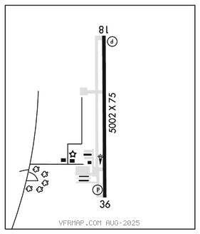
BLYTHEVILLE MUNI (HKA)(KHKA) 3 E UTC–6(–5DT) N35°56.42′ W89°49.85′
256 B TPA–See Remarks NOTAM FILE HKA

RWY 18–36: H5002X75 (ASPH) S–15 MIRL
RWY 18: PAPI(P4L)–GA 3.0° TCH 48′.
RWY 36: PAPI(P4L)–GA 3.0° TCH 48′.
SERVICE: S2 FUEL 100LL, JET A LGT ACTVT MIRL Rwy 18–36–CTAF. PAPI Rwy 18 and 36 opr continuously. Wind indicator lgt temporarily OTS.
AIRPORTREMARKS: Attended 1330–2330Z‡. For arpt attendant aft hrs call 870–532–7309. Numerous agricultural acft ops from Feb–Nov 250 ft AGL and below, right and left TPA.
AIRPORT MANAGER: 870-763-0200
WEATHER DATA SOURCES: ASOS 135.025 (870) 763–8206.
COMMUNICATIONS: CTAF/UNICOM 123.05
®MEMPHIS CENTER APP/DEP CON 134.65
CLEARANCE DELIVERY PHONE: For CD ctc Memphis ARTCC at 901-368-8453/8449.
RADIO AIDS TO NAVIGATION: NOTAM FILE DYR.
DYERSBURG (L) TACAN Chan 115 DYR (116.8) N36°01.11′ W89°19.06′ 257° 25.4 NM to fld. 389/3E.