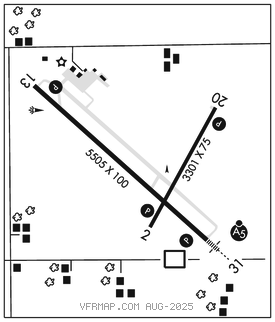
FAIRMONT MUNI (FRM)(KFRM) 2 SE UTC–6(–5DT) N43°38.64′ W94°24.94′
1162 B NOTAM FILE FRM

RWY 13–31: H5505X100 (ASPH–PFC) S–35, D–40 HIRL
RWY 13: REIL. PAPI(P4L)–GA 3.0° TCH 43′. Road.
RWY 31: MALSR. PAPI(P4L)–GA 3.0° TCH 40′.
RWY 02–20: H3301X75 (ASPH) S–12 MIRL
RWY 02: REIL. PAPI(P4L)–GA 3.0° TCH 25′.
RWY 20: REIL. PAPI(P4L)–GA 3.0° TCH 40′.
SERVICE: FUEL 100LL, JET A LGT HIRL Rwy 13–31 and MIRL Rwy 02–20 preset to low ints, to incr ints and ACTVT MALSR Rwy 31; REIL Rwy 02, 13, and 20; PAPI Rwy 02, 13, 20, and 31–CTAF. For twy lgts key 122.8, 3 times for 30% and 7 times for 100%.
AIRPORT REMARKS: Attended Mon–Fri 1400–2300Z‡. JET A and 100LL avbl 24hrs with credit card. Migratory bird hazard spring and fall, gulls on and invof arpt. Rwy 02–20 weeds growing thru lrg cracks. For transient storage ctc amgr.
AIRPORT MANAGER: 507-235-6160
WEATHER DATA SOURCES: AWOS–3PT 120.025 (507) 238–1562.
COMMUNICATIONS: CTAF/UNICOM 122.8
RCO 122.3 (PRINCETON RADIO)
®MINNEAPOLIS CENTER APP/DEP CON 127.75
AIRSPACE: CLASS E svc 1130–0130Z‡ Mon–Fri, 1130–1900Z‡ Sat, 1600–2300Z‡ Sun; other times CLASS G.
RADIO AIDS TO NAVIGATION: NOTAM FILE FRM.
MONTZ NDB (LOMW) 420 FQ N43°34.42′ W94°19.08′ 311° 6.0 NM to fld. 1151/4E. NDB unmonitored.
(DH) DME 114.25 FNX Chan 89(Y) N43°38.27′ W94°24.79′ at fld. 1214.
ILS 111.1 I–FQJ Rwy 31. Class IT. LOM MONTZ NDB. Unmonitored. LOM unmonitored.