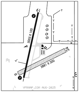
EMPORIA MUNI (EMP)(KEMP) 4 S UTC–6(–5DT) N38°19.83′ W96°11.40′
1208 B NOTAM FILE EMP

RWY 01–19: H5005X100 (ASPH–CONC) S–30, D–45 PCN 11 F/C/X/U MIRL
RWY 01: REIL. PAPI(P4L)–GA 3.0° TCH 41′.
RWY 19: REIL. PAPI(P4R)–GA 3.0° TCH 37′.
RWY 06–24: 3881X300 (TURF)
SERVICE: FUEL 100LL, JET A, MOGAS LGT ACTIVATE PAPI and REIL Rwys 01 and 19–CTAF. ACTIVATE MIRL Rwy 01–19 after 0000Z‡–CTAF.
AIRPORT REMARKS: Attended Mar–Oct 1330–0000Z‡, Nov–Feb 1330–2330Z‡. 24 hr fuel avbl for MOGAS & 100LL. Jet A avbl on request. Ultralight activity on and invof arpt. Windsock at segmented circle not lighted. Windsock lighted approx. 250′ east of Rwy 01–19 and 1000′ south of AER 19. Rwy 01–19 line of sight between rwy ends obstructed. ASOS mast 27′ AGL located approximately 700′ west of Rwy 01–19 and 1,150′ north of AER 01. 33′ tree outside of and adj to apch sfc 100′ from Rwy 24 thld. Rwy 06–24 ends and edges marked with orange and white corrugated panels. Rwy 06–24 soft when wet. Center 60′ of width in good condition.
AIRPORT MANAGER: 620-343-5600
WEATHER DATA SOURCES: ASOS 126.125 (620) 343–3733.
COMMUNICATIONS: CTAF/UNICOM 122.8
RCO 122.3 (WICHITA RADIO)
®KANSAS CITY CENTER APP/DEP CON 127.725
CLEARANCE DELIVERY PHONE: For CD if una to ctc on FSS freq, ctc Kansas City ARTCC at 913-254-8508.
AIRSPACE: CLASS E svc 1200–0400Z‡; other times CLASS G.
RADIO AIDS TO NAVIGATION: NOTAM FILE EMP.
(VL) (H) VORTACW 112.8 EMP Chan 75 N38°17.47′ W96°08.29′ 306° 3.4 NM to fld. 1222/8E.
TACAN AZIMUTH unusable:
205°–245° byd 40 NM
DME unusable:
205°–245° byd 40 NM
VOR unusable:
210°–245° byd 40 NM
310°–320° byd 40 NM