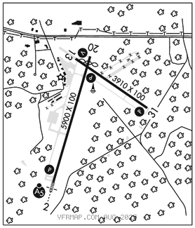
DANVILLE RGNL (DAN)(KDAN) 3 E UTC–5(–4DT) N36°34.35′ W79°20.18′
571 B TPA–See Remarks NOTAM FILE DAN

RWY 02–20: H5900X100 (ASPH–GRVD) S–90, D–130, 2S–165 HIRL 0.5% up N
RWY 02: MALSR. PAPI(P4L)–GA 3.0° TCH 55′. Tree.
RWY 20: REIL. PAPI(P4L)–GA 3.0° TCH 47′. Thld dsplcd 300′. Tree.
RWY 13–31: H3910X100 (ASPH) S–90, D–130, 2S–165 MIRL 1.1% up NW
RWY 13: REIL. VASI(V2L)–GA 3.0° TCH 28′. Tree.
RWY 31: REIL. PAPI(P2L)–GA 4.0° TCH 76′. Trees.
RUNWAY DECLARED DISTANCE INFORMATION
RWY 02: TORA–5600 TODA–5900 ASDA–5600 LDA–5600
RWY 20: TORA–5900 TODA–5900 ASDA–5900 LDA–5600
SERVICE: S4 FUEL 100LL, JET A+ LGT ACTIVATE HIRL Rwy 02–20, MIRL Rwy 13–31, REIL Rwy 13, Rwy 31, and Rwy 20, MALSR Rwy 02, VASI Rwy 13 and PAPI Rwy 02, Rwy 20 and Rwy 31–CTAF.
AIRPORT REMARKS: Attended 1200–0000Z‡. Arpt unattended Christmas Day. Birds and deer on and invof arpt. Trees penetrating 7:1 transitional sfc of Rwy 31 both sides, first 1000′. Ctc arpt administration prior to conducting specialized aero activities 434–799–5110. TPA–1371 (800) lgt acft, 2071 (1500) turbine acft. Rwy 02 is designated calm wind rwy.
AIRPORT MANAGER: 434-799-5110
WEATHER DATA SOURCES: ASOS 128.125 (434) 799–1701.
COMMUNICATIONS: CTAF/UNICOM 123.05
RCO 122.2 (LEESBURG RADIO)
®WASHINGTON CENTER APP/DEP CON 124.05
CLEARANCE DELIVERY PHONE: For CD if una to ctc on FSS freq, ctc Washington ARTCC at 703-771-3587.
AIRSPACE: CLASS E svc continuous.
RADIO AIDS TO NAVIGATION: NOTAM FILE DCA.
SOUTH BOSTON (L) (L) VORTAC 110.4 SBV Chan 41 N36°40.50′ W79°00.87′ 254° 16.7 NM to fld. 5205W.
ILS 110.7 I–DAN Rwy 02. Class IE.