COVINGTON
CINCINNATI/NORTHERN KENTUCKY INTL (CVG)(KCVG) 8 SW UTC–5(–4DT) N39°02.93′ W84°40.07′ 896 B LRA ARFF Index–See Remarks NOTAM FILE CVG

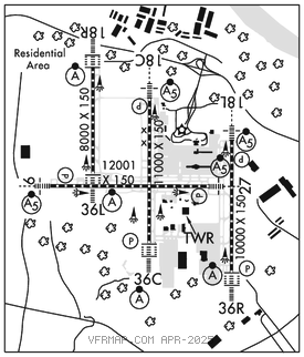
RWY 09–27: H12001X150 (ASPH–CONC–GRVD) S–120, D–250, 2S–175, 2D–550, 2D/2D2–875 PCN 101R/B/W/T HIRL CL
RWY 09: MALSR. TDZL. PAPI(P4L)–GA 3.0° TCH 70′. RVR–TR 0.3% down.
RWY 27: MALSR. PAPI(P4L)–GA 3.0° TCH 67′. RVR–TR
RWY 18C–36C: H11000X150 (ASPH–CONC–GRVD) S–120, D–250, 2S–175, 2D–550, 2D/2D2–875 PCN 112F/C/W/T HIRL CL
RWY 18C: MALSR. TDZL. PAPI(P4R)–GA 3.0° TCH 71′. RVR–TMR
RWY 36C: ALSF2. TDZL. PAPI(P4L)–GA 3.0° TCH 77′. RVR–TMR 0.6% up.
RWY 18L–36R: H10000X150 (CONC–GRVD) S–120, D–250, 2S–175, 2D–550, 2D/2D2–875 PCN 127R/B/W/T HIRL CL
RWY 18L: MALSR. TDZL. PAPI(P4L)–GA 3.0° TCH 71′. RVR–TMR
RWY 36R: ALSF2. TDZL. PAPI(P4R)–GA 3.0° TCH 70′. RVR–TMR
RWY 18R–36L: H8000X150 (CONC–GRVD) S–120, D–250, 2D–550, 2D/2D2–875 PCN 170R/B/W/T HIRL CL
RWY 18R: ALSF2. TDZL. RVR–TMR
RWY 36L: ALSF2. TDZL. RVR–TMR
RUNWAY DECLARED DISTANCE INFORMATION
RWY 09: TORA–12000 TODA–12000 ASDA–11640 LDA–11640
RWY 27: TORA–12000 TODA–12000 ASDA–12000 LDA–12000
SERVICE: S4 FUEL 100LL, JET A
NOISE: Noise sens area N & S of arpt; rwy asgn 0300–1200Z‡ based on noise abatement. Successive or simul dep fm Rwy 18L, 18C, 36L, 36C & 36R apvd with course dvrg bgn no further than 2 mi fm EOR due to noise abatement. NOTE: See Special Notices–NOISE ABATEMENT PROCEDURES Covington, KY, Cincinnati/Northern Kentucky Intl Airport (CVG).
AIRPORT REMARKS: Attended continuously. Birds on and invof the arpt. Twys rstrd to 15 mph or less with wingspan 214′ or more. Rwy 09–27 W 4200′ and E 750′ conc; remainder asph overlay. Flight Notification Service (ADCUS) avbl. Class I, ARFF Index C. ARFF Index D/E avbl upon req. Rwy 18R–36L clsd to pax acft wingspan gtr than 140 ft. ASSC in use. Operate transponders with altitude reporting mode and ADS–B (if equipped) enabled on all airport surfaces.
AIRPORT MANAGER: 859-767-3151
WEATHER DATA SOURCES: ASOS 134.375 (859) 767–8210. TDWR.
COMMUNICATIONS: D–ATIS ARR 134.375 D–ATIS DEP 135.3 UNICOM 122.95
®APP CON 119.7 (090°–269°) 123.875 (270°–089°)
TOWER 118.3 (Rwy 09–27 and Rwy 18C–36C) 118.975 (Rwy 18L–36R) 133.325 (Rwy 18R–36L)
GND CON 121.7 CLNC DEL 127.175
®DEP CON 128.7 (181°–360°) 126.65 (001°–180°)
RAMP CTL 130.90 (Ramp 1N / 1S Txl & Ramp 2N / 2S Txl) 130.375 (Ramp 3 Txl & N Txl) 129.475 (DHL Ramp) 130.5 (AMZ Ramp Ctl)
CPDLC (LOGON KUSA)
PDC
AIRSPACE: CLASS B See VFR Terminal Area Chart.
RADIO AIDS TO NAVIGATION: NOTAM FILE CVG.
(L) (L) VORTACW 117.3 CVG Chan 120 N39°00.96′ W84°42.20′ 044° 2.6 NM to fld. 878/4W.
ILS/DME 111.9 I–URN Chan 56 Rwy 09. Class ID.
ILS/DME 111.55 I–SIC Chan 52(Y) Rwy 18C. Class IIE.
ILS/DME 110.15 I–CIZ Chan 38(Y) Rwy 18L. Class IA. LOC unusable byd 25° left of course.
ILS/DME 110.75 I–CJN Chan 44(Y) Rwy 18R. Class IIE.
ILS 108.7 I–JDP Rwy 27. Class IIE. LOC unusable byd 20° right of course.
ILS/DME 109.9 I–CVG Chan 36 Rwy 36C. Class IIIE.
ILS/DME 110.75 I–VAC Chan 44(Y) Rwy 36L. Class IIE.
ILS/DME 110.35 I–EEI Chan 40(Y) Rwy 36R. Class IIIE.