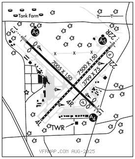
BATON ROUGE METRO, RYAN FLD (BTR)(KBTR) 4 N UTC–6(–5DT) N30°31.98′ W91°08.99′
70 B LRA ARFF Index–See Remarks NOTAM FILE BTR MON Airport

RWY 04L–22R: H7500X150 (CONC–GRVD) S–120, D–170, 2S–175, 2D–300 PCN 70 R/A/W/T HIRL CL
RWY 04L: RVR–TR Pole.
RWY 22R: MALSR. TDZL. PAPI(P4L)–GA 3.0° TCH 56′. RVR–TR Rgt tfc.
RWY 13–31: H7005X150 (ASPH–GRVD) S–120, D–170, 2S–175, 2D–300 PCN 95 F/C/X/T HIRL
RWY 13: MALSR. RVR–T Thld dsplcd 597′. Pole.
RWY 31: MALS. VASI(V4L)–GA 3.0° TCH 64′. RVR–R Thld dsplcd 314′. Road.
RWY 04R–22L: H3799X75 (ASPH) S–30, D–45 PCN 26 F/C/X/T MIRL
RWY 04R: Rgt tfc.
RUNWAY DECLARED DISTANCE INFORMATION
RWY 04L:TORA–7500 TODA–7500 ASDA–7500 LDA–7500
RWY 04R:TORA–3799 TODA–3799 ASDA–3799 LDA–3799
RWY 13: TORA–7004 TODA–7004 ASDA–6317 LDA–5720
RWY 22L:TORA–3799 TODA–3799 ASDA–3799 LDA–3799
RWY 22R:TORA–7500 TODA–7500 ASDA–7500 LDA–7500
RWY 31: TORA–7004 TODA–7004 ASDA–6407 LDA–6094
SERVICE: S4 FUEL 100LL, JET A OX 1, 3 LGT ACTVT MALSR Rwy 22R & 13 and MALS Rwy 31–CTAF. When ATCT clsd HIRL Rwys 13–31 & 04L–22R preset low intst; to incr intst ACTVT–CTAF. MIRL Rwy 04R–22L not avbl.
AIRPORTREMARKS: Attended 1100–0600Z‡. Migratory birds on and in vicinity of arpt during months of Mar, Apr, Sep and Oct. Class I ARFF Index C, 24 hrs PPR for unscheduled air carrier ops with more than 30 passenger seats 0600–1100Z‡, call arpt manager 225–355–2068/0333. When twr clsd use 121.9 to ctc ARFF for emergency request. Rwy 04R–22L not avbl for air carrier ops with more than 30 passenger seats. Rwy 04R–22L and Twy E are similar in appearance. Use caution when exiting Rwy 13–31. Ramp and twy lane adjacent to the commercial air carrier terminal building is limited to commercial air carrier and passenger airtaxi acft only. Twy E weight restrictions: single 44,000 lbs, dual 55,000 lbs, dual tandem 93,000 lbs. Twy E, Twy F btn Rwy 04R–22L and AER 31 not avbl for skedd acr ops. Twy F btn Rwy 04–22L and 31 RDCS to 40 ft wid. Dsgnd free pub use prkg for GA acft in the back row of the S ramp.
AIRPORT MANAGER: 225-355-0333
WEATHER DATA SOURCES: ASOS (225) 370–8455 LLWAS.
COMMUNICATIONS: CTAF 118.45 ATIS 125.2 225–354–2170 UNICOM 122.95
RCO 122.2 (DE RIDDER RADIO) ® APP/DEP CON 120.3 WEST 133.225 EAST (1100–0600Z‡)
®HOUSTON CENTER APP/DEP CON 126.35 (0600–1100Z‡)
TOWER 118.45 (1100–0600Z‡) GND CON 121.9 CLNC DEL 119.4
CLEARANCE DELIVERY PHONE: For CD if una to ctc on FSS freq, ctc Houston ARTCC at 281-230-5622.
AIRSPACE: CLASS C svc ctc APP CON svc (per TWR/NOTAM 1100–0600Z‡); other times CLASS E.
RADIO AIDS TO NAVIGATION: NOTAM FILE BTR.
FIGHTING TIGER (VL) (L) VORTACW 116.5 LSU Chan 112 N30°29.11′ W91°17.64′ 063° 8.0 NM to fld. 206E.
RUNDI NDB (LOMW) 284 BT N30°34.98′ W91°12.66′ 133° 4.4 NM to fld. 69/0E.
ILS/DME 110.3 I–BTR Chan 40 Rwy 13. Class ID. LOM RUNDI NDB. Unmonitored when ATCT closed.
ILS/DME 108.7 I–CLZ Chan 24 Rwy 22R. Class IIE. Unmonitored when ATCT closed.
ASR (1100-0600Z‡)