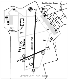
BIG SPRING/MC MAHON–WRINKLE (BPG)(KBPG) 2 SW UTC–6(–5DT) N32°12.76′
W101°31.30′ 2573 B NOTAM FILE BPG

RWY 17–35: H8803X100 (CONC) S–60, D–150, 2D–200 MIRL
RWY 17: SSALS. PAPI(P4L)–GA 3.0° TCH 45′. Rgt tfc.
RWY 35: PAPI(P4L)–GA 3.0° TCH 36′. 0.3% up S.
RWY 06–24: H4601X75 (ASPH) MIRL 0.6% up NE
RWY 06: PAPI(P2L)–GA 3.0° TCH 40′. Rgt tfc.
RWY 24: PAPI(P2L)–GA 3.0° TCH 40′. Fence.
SERVICE: S4 FUEL 100LL, JET A LGT MIRL Rwys 06–24 and 17–35 preset low intst; to incr intst and ACTVT SSALS Rwy 17–CTAF.
AIRPORTREMARKS:Attended Mon–Fri 1400–2300Z‡. Prairie dogs on rwys and twys. Sandhill Cranes xng in the spring and fall. 100LL and Jet–A full and self serve. FBO 432–264–7124. Aft hrs 432–935–1238.
AIRPORT MANAGER: 432-264-2362
WEATHER DATA SOURCES: AWOS–3PT 118.025 (432) 264–7475.
COMMUNICATIONS: CTAF/UNICOM 122.8
RCO 122.4 (SAN ANGELO RADIO)
®FORT WORTH CENTER APP/DEP CON 133.7
CLEARANCE DELIVERY PHONE: For CD ctc Fort Worth ARTCC at 817-858-7584.
RADIO AIDS TO NAVIGATION: NOTAM FILE BPG.
(VL) (H) VORTACW 117.2 BGS Chan 119 N32°23.14′ W101°29.02′ 180° 10.5 NM to fld. 267011E.