WILKES–BARRE/SCRANTON INTL (AVP)(KAVP) 5 SW UTC–5(–4DT) N41°20.31′
W75°43.40′ 962 B LRA ARFF Index–See Remarks NOTAM FILE AVP

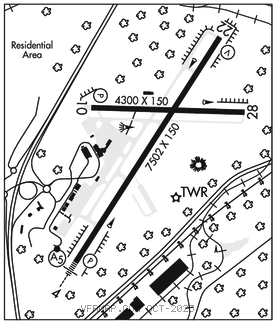
RWY 04–22: H7502X150 (ASPH–GRVD) S–133, D–173, 2D–300 PCN 45 F/A/X/T HIRL 0.7% up SW
RWY 04: MALSR. PAPI(P4R)–GA 3.0° TCH 58′. RVR–TR
RWY 22: REIL. VASI(V4L)–GA 3.0° TCH 54′. RVR–TR Trees. Rgt tfc.
RWY 10–28: H4300X150 (ASPH–GRVD) S–58, D–80, 2S–101, 2D–125 PCN 34 F/C/X/T MIRL 0.3% up E
RWY 10: REIL. PAPI(P2L)–GA 3.0° TCH 43′. Rgt tfc.
RWY 28: REIL. Trees. Rgt tfc.
RUNWAY DECLARED DISTANCE INFORMATION
RWY 04: TORA–7502 TODA–7502 ASDA–7502 LDA–7502
RWY 10: TORA–4300 TODA–4300 ASDA–4300 LDA–4300
RWY 22: TORA–7502 TODA–7502 ASDA–7502 LDA–7502
RWY 28: TORA–4300 TODA–4300 ASDA–4300 LDA–4300
ARRESTING GEAR/SYSTEM
RWY 04: EMAS
RWY 22: EMAS
SERVICE: S3 FUEL 100LL, JET A OX 2, 4
AIRPORT REMARKS: Attended continuously. Deer and birds on and invof arpt. Rwy 04–22 precipitous drop–off each rwy end. Class I, ARFF Index B. Index C ARFF equipment avbl upon request call 570–602–2040. Unlgtd twr 1130′ 1.3 miles east AER 28, unlgtd twr 1463′ 1.7 miles east AER 28, unlgtd twr 1652′ 2.4 miles east AER 28. Rwy 28 unlgtd high terrain trees, 1155′ MSL 0.91 miles east AER 28, 1463′ MSL 1.49 miles east–southeast AER 28, 1667′ MSL 2.25 miles east AER 28, 1920′ MSL 2.84 miles east AER 28. For FBO svcs 0500–1000Z‡ local Mon–Fri and 0200–0500Z‡ local Sat–Sun call (570) 457–4485. Ldg fee. Flight Notification Service (ADCUS) avbl.
AIRPORT MANAGER: 570-602-2000
WEATHER DATA SOURCES: ASOS (570) 456–5433
COMMUNICATIONS: UNICOM 122.95 ATIS 135.75
RCO 122.2 (WILLIAMSPORT RADIO)
®APP/DEP CON 120.95 (280°–100°) 126.3 (101°–279°)
TOWER 120.1 GND CON 121.9
AIRSPACE: CLASS D.
TRSA svc ctc APP CON within 20 NM
RADIO AIDS TO NAVIGATION: NOTAM FILE AVP.
(L) (L) VORTACW 111.6 LVZ Chan 53 N41°16.37′ W75°41.37′ 349° 4.2 NM to fld. 2118/10W.
VOR unusable:
290°–305° byd 15 NM blo 6,000′
ILS/DME 109.9 I–AVP Chan 36 Rwy 04. LOC unusable byd 20° right of course.
ILS/DME 109.9 I–IZK Chan 36 Rwy 22.