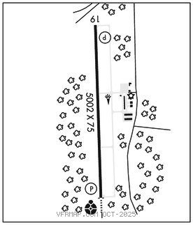
SOUTH HILL
MECKLENBURG–BRUNSWICK RGNL (AVC)(KAVC) 4 SE UTC–5(–4DT) N36°41.30′ W78°03.27′ 441 B TPA–1841(1400) NOTAM FILE AVC

RWY 01–19: H5002X75 (ASPH) S–25 MIRL 1.3% up N
RWY 01: ODALS. REIL. PAPI(P2L)–GA 3.0° TCH 40′. Tree.
RWY 19: REIL. PAPI(P2L)–GA 3.0° TCH 40′. Trees.
SERVICE: S2 FUEL 100LL, JET A LGT ACTIVATE REIL Rwy 01–19, MIRL Rwy 01–19 preset low ints, for higher ints and to ACTIVATE ODALS––CTAF. Bcn dusk–dawn.
AIRPORT REMARKS: Attended 1300–2200Z‡. Arpt clsd on fed hols. Deer and birds on and invof arpt. 24 hr fuel avbl by credit card. Corporate hangar taxilane rstd to acft with wingspan no larger than 55′.
AIRPORT MANAGER: 434-774-8023
WEATHER DATA SOURCES: AWOS–3 127.525 (434) 729–2229.
COMMUNICATIONS: CTAF/UNICOM 122.8
®WASHINGTON CENTER APP/DEP CON 118.75
CLEARANCE DELIVERY PHONE: For CD ctc Washington ARTCC at 703-771-3587.
RADIO AIDS TO NAVIGATION: NOTAM FILE DCA.
LAWRENCEVILLE (L) DME 112.9 LVL Chan 76 N36°49.08′ W77°54.18′ 223° 10.7 NM to fld. 350.
DME unusable:
Blw 3,000′
LOC/DME 110.5 I–AVC Chan 42 Rwy 01. Unmonitored when arpt unatndd.