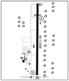
SLIDELL (ASD)(KASD) 4 NW UTC–6(–5DT) N30°20.78′ W89°49.25′
28 B NOTAM FILE ASD

RWY 18–36: H5002X100 (ASPH) S–48 MIRL
RWY 18: REIL. PAPI(P2L)–GA 3.0° TCH 50′. Thld dsplcd 944′. Trees.
RWY 36: REIL. PAPI(P2L)–GA 3.0° TCH 50′. Trees.
RUNWAY DECLARED DISTANCE INFORMATION
RWY 18: TORA–5001 TODA–5001 ASDA–5001 LDA–4057
RWY 36: TORA–5001 TODA–5001 ASDA–5001 LDA–5001
SERVICE: S4 FUEL 100LL, JET A+ OX3 LGT MIRL Rwy 18–36, REIL Rwy 18 and Rwy 36 preset low ints dusk–dawn, to increase ints ACTIVATE–CTAF.
AIRPORT REMARKS: Attended 1300–2200Z‡. Arpt unatndd Thanksgiving, Christmas, New Years Day. Parachute Jumping. Wildlife on and invof rwy. 100LL avbl 24 hrs with credit card. For JET fuel after hrs call 985–259–2460. Parachute jumping area on weekends.
AIRPORT MANAGER: 985-641-7590
WEATHER DATA SOURCES: ASOS 132.475 (985) 643–7263.
COMMUNICATIONS: CTAF/UNICOM 122.8
®NEW ORLEANS APP/DEP CON 133.15
GCO 135.075 (NEW ORLEANS APCH and DE RIDDER FSS)
CLEARANCE DELIVERY PHONE: For CD ctc New Orleans Apch at 504-471-4350.
RADIO AIDS TO NAVIGATION: NOTAM FILE GWO.
PICAYUNE (L) (L) VORW/DME 113.95 PCU Chan 86(Y) N30°33.67′ W89°43.83′ 195° 13.7 NM to fld. 705E.
VOR unusable:
011°–055° byd 40 NM blo 8,000′
079°–102° byd 40 blo 8,000′
285°–305° byd 6 NM blo 4,000′
325°–076° byd 26 NM blo 2,500′
DME unusable:
078°–180° byd 32 NM blo 3,000′
331°–064° byd 27 NM blo 4,000′