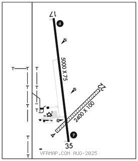
ATWOOD–RAWLINS CO CITY–COUNTY (ADT)(KADT) 2 N UTC–6(–5DT) N39°50.42′ W101°02.55′
2991 B NOTAM FILE ICT

RWY 17–35: H5000X75 (ASPH) S–12.5, D–12.5 MIRL
RWY 17: REIL. PAPI(P2L)–GA 3.0° TCH 40′.
RWY 35: REIL. PAPI(P2R)–GA 3.0° TCH 40′.
RWY 04–22: 2400X100 (TURF)
RWY 04: P–line.
SERVICE: FUEL 100LL LGT ACTVT REIL Rwy 17 and 35; PAPI Rwy 17 and 35; MIRL Rwy 17–35–CTAF.
AIRPORT REMARKS: Unattended. 24 hr self svc fuel. Rwy 03–21 acute difference in sfc elev at int with Rwy 17 and 35. Sug ops be conducted E of that int. Public phone avbl 24 hrs.
AIRPORT MANAGER: (785) 626-0297
WEATHER DATA SOURCES: AWOS–3 118.675 (785) 626–3572.
COMMUNICATIONS: CTAF/UNICOM 122.7
®DENVER CENTER APP/DEP CON 132.7
CLEARANCE DELIVERY PHONE: For CD ctc Denver ARTCC at 303-651-4257.
RADIO AIDS TO NAVIGATION: NOTAM FILE OLU.
HAYES CENTER (VH) (H) VORTAC 117.7 HCT Chan 124 N40°27.24′ W100°55.41′ 177° 37.2 NM to fld. 301011E.