OAKDALE
ALLEN PARISH (ACP)(KACP) 4 S UTC–6(–5DT) N30°45.03′ W92°41.31′ 107 B NOTAM FILE DRI
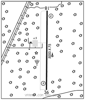
RWY 18–36: H5000X75 (ASPH) S–11 MIRL
RWY 18: REIL. PAPI(P2L)–GA 3.0° TCH 50′. Trees.
RWY 36: REIL. PAPI(P2L)–GA 3.0° TCH 51′. Trees.
SERVICE: FUEL 100LL, JET A LGT MIRL Rwy 18–36; REIL Rwy 18 and Rwy 36 preset low ints dusk to dawn, to incr ints ACTVT–CTAF.
AIRPORT REMARKS: Attended continuously. Fuel avbl self service with credit card. Standing water on rwy at midfield after rain. Ctc arpt mgr for dsngd ramp space for pub use at arpt.
AIRPORT MANAGER: 318-215-0090
WEATHER DATA SOURCES: AWOS–3PT 118.275 (318) 215–9728.
COMMUNICATIONS: CTAF/UNICOM 122.8
®POLK APP/DEP CON 123.7
GCO 135.075 (POLK APCH CTL and Flight Services)
CLEARANCE DELIVERY PHONE: For CD if una via GCO, ctc Polk Apch at 337-531-2352.
RADIO AIDS TO NAVIGATION: NOTAM FILE AEX.
ALEXANDRIA (VH) (H) VORTACW 116.1 AEX Chan 108 N31°15.40′ W92°30.06′ 195° 31.8 NM to fld. 76/3E.
VOR unusable:
035°–065° blo 2,000′
066°–094° byd 35 NM blo 3,000′
115°–120° byd 40 NM blo 18,000′
130°–215° byd 40 NM
185°–200° byd 35 NM blo 3,000′
201°–214° byd 35 NM blo 2,000′
215°–260° blo 2,000′
220°–229° byd 40 NM
230°–240° byd 40 NM blo 8,000′
241°–245° byd 40 NM
246°–255° byd 40 NM blo 8,000′
261°–285° byd 35 NM blo 2,000′
265°–270° byd 49 NM blo 18,000′
271°–285° byd 40 NM
286°–290° byd 40 NM blo 18,000′
300°–304° byd 40 NM blo 5,000′
300°–304° byd 68 NM
305°–325° byd 40 NM
340°–080° byd 40 NM
357°–034° byd 35 NM blo 3,000′