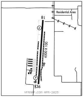
MIDLOTHIAN/WAXAHACHIE
MID–WAY RGNL (JWY)(KJWY) 5 SE UTC–6(–5DT) N32°27.50′ W96°54.75′ 727 B NOTAM FILE JWY

RWY 18–36: H6500X100 (ASPH) S–30, D–90 MIRL 0.6% up N
RWY 18: REIL. PAPI(P4R)–GA 3.0° TCH 40′.
RWY 36: PAPI(P4L)–GA 3.0° TCH 40′.
SERVICE: S4 FUEL 100LL, JET A LGT Actvt REIL Rwy 18; MIRL Rwy 18–36–CTAF. PAPI Rwy 18 and Rwy 36 opr consly.
AIRPORT REMARKS: Attended Mar–Oct Mon–Sat 1400–0100Z‡, Sun 1500–0100Z‡. Attended Nov–Feb Mon–Sat 1400–0000Z‡, Sun 1500–0000Z‡. For fuel and services after hrs call 214–762–8286 or 972–979–5723. Glider ops on arpt.
AIRPORT MANAGER: 972-923-0080
WEATHER DATA SOURCES: AWOS–3P 119.575 (972) 227–0471.
COMMUNICATIONS: CTAF/UNICOM 122.975
®LONE STAR APP/DEP CON 125.2
CLEARANCE DELIVERY PHONE: For CD ctc Regional Apch at 972-615-2799.
RADIO AIDS TO NAVIGATION: NOTAM FILE FTW.
MAVERICK (VH) (H) VORW/DME 113.1 TTT Chan 78 N32°52.15′ W97°02.43′ 159° 25.4 NM to fld. 536/6E. All acft arriving DFW are requested to turn DME off until departure due to traffic overload of Maverick DME
DME unusable:
180°–190° byd 10 NM
240°–260° byd 20 NM blo 3,500′
VOR unusable:
105°–110° byd 40 NM