ABBEVILLE CHRIS CRUSTA MEML (IYA)(KIYA) 3 E UTC–6(–5DT) N29°58.55′
W92°05.05′ 16 B TPA–See Remarks NOTAM FILE DRI
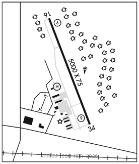
RWY 16–34: H5000X75 (ASPH) S–17 MIRL
RWY 16: REIL. PAPI(P2L)–GA 3.0° TCH 50′. Fence.
RWY 34: REIL. PAPI(P2L)–GA 3.0° TCH 50′. Trees.
SERVICE: S4 FUEL 100LL, JET A LGT Dusk–Dawn. MIRL Rwy 16–34; REIL Rwy 16 and 34 preset on low intst dusk to dawn; to incr intst ACTVT–CTAF.
AIRPORT REMARKS: Attended daylight hours. TPA–352 (336) ultralight within 3 miles of arpt. Ctc arpt mgr for dsngd ramp space for pub use at arpt.
AIRPORT MANAGER: (337) 898-4206
WEATHER DATA SOURCES: AWOS–3PT 118.875 (337) 892–0526.
COMMUNICATIONS: CTAF/UNICOM 122.8
®LAFAYETTE APP/DEP CON 121.1 (1130–0430Z‡)
HOUSTON CENTER APP/DEP CON 126.35 (0430–1130Z‡)
GCO 135.075 (LAFAYETTE APCH and DE RIDDER FSS)
CLEARANCE DELIVERY PHONE: For CD ctc Lafayette Apch at 337-262-2729, when Apch clsd ctc Houston ARTCC at 281-230-5622.
RADIO AIDS TO NAVIGATION: NOTAM FILE LFT.
LAFAYETTE (L) (L) VORTACW 109.8 LFT Chan 35 N30°11.63′ W91°59.55′ 197° 13.9 NM to fld. 36/3E.
TACAN AZIMUTH unusable:
295°–320° blo 4,000′
NDB (MHW) 230 BNZ N30°03.67′ W92°07.40′ 156° 5.5 NM to fld. 13/2E. NOTAM FILE DRI.
LOC 110.95 I–IYA Rwy 16. • • • • • • • • • • • • • • • • • •
HELIPAD H1: H80X80 (CONC)