NEW ROADS
FALSE RIVER RGNL (HZR)(KHZR) 2 NW UTC–6(–5DT) N30°43.10′ W91°28.72′ 39 B TPA–See Remarks NOTAM FILE DRI
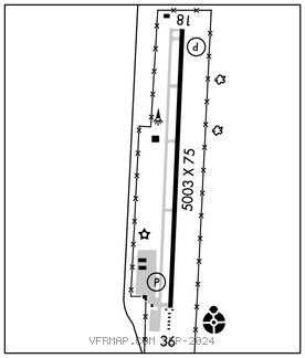
RWY 18–36: H5003X75 (ASPH) S–30 MIRL
RWY 18: REIL. PAPI(P2L)–GA 3.0° TCH 50′.
RWY 36: ODALS. PAPI(P2L)–GA 3.0° TCH 50′.
SERVICE: FUEL 100LL LGT ACTIVATE REIL Rwy 18–122.8. MIRL Rwy 18–36; ODALS Rwy 36 preset low ints, to incr ints –122.8 Dual lighting system ops in effect due to testing of LED MIRL and twy lgts indef.
AIRPORT REMARKS: Attended Mon–Fri 1400–2200Z‡. For attendant after hrs call 225–978–8367. Fuel avbl 24 hrs self svc with credit card. TPA–299 (260) ultralight, 499 (460) helicopter, 999 (960) fixed wing within 3 NM of arpt. Rwy 18–36 surface condition not reported 0300–1900Z‡ Mon–Fri and 1100–1059Z‡ on weekends and holidays.
AIRPORT MANAGER: 225-638-3192
WEATHER DATA SOURCES: AWOS–3PT 121.250 (225) 638–3107.
COMMUNICATIONS: CTAF/UNICOM 122.8
®BATON ROUGE APP/DEP CON 120.3 (1100–0600Z‡)
®HOUSTON CENTER APP/DEP CON 126.35 (0600–1100Z‡)
CLEARANCE DELIVERY PHONE: For CD ctc Houston ARTCC at 281-230-5622.
RADIO AIDS TO NAVIGATION: NOTAM FILE BTR.
FIGHTING TIGER (VL) (L) VORTACW 116.5 LSU Chan 112 N30°29.11′ W91°17.64′ 320° 16.9 NM to fld. 206E.
LOC/DME 111.9 I–HZR Chan 56 Rwy 36.