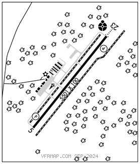
WAYNE EXEC JETPORT (GWW)(KGWW) 3 N UTC–5(–4DT) N35°27.63′ W77°57.90′
134 B NOTAM FILE GWW

RWY 05–23: H5501X100 (ASPH) S–51, D–71 PCN 19 F/C/X/T MIRL
RWY 05: REIL. PAPI(P4L)—GA 3.0° TCH 40′. Trees.
RWY 23: ODALS. REIL. PAPI(P4L)—GA 3.0° TCH 44′. Trees.
SERVICE: S4 FUEL 100LL, JET A1+ LGT Actvt REIL Rwy 05 and 23; ODALS Rwy 23; MIRL Rwy 05–23—–CTAF. PAPIs Rwy 05 and 23 opers cons. Rwy 23 PAPI not coincidental with ILS Rwy 23 GP.
AIRPORT REMARKS: Attended Mon–Sat 1300–2200Z‡, Sun 1800–2200Z‡. Unatndd federal hol. For emerg svc after hrs call 919–734–7630. Bird activity invof arpt. Ultralight; glider and parachute activity PPR call 919–734–7630. 24 hr self svc fuel avbl with credit card. For emergency svc after hours call 919–734–7630 or 919–222–9191. Helicopter ops on twy leading to T–hangars. Helipad on twy with tfc cones and flags.
AIRPORT MANAGER: 919-734-7630
WEATHER DATA SOURCES: AWOS–3P 118.975 (919) 731–4473.
COMMUNICATIONS: CTAF/UNICOM 122.975
®SEYMOUR JOHNSON APP/DEP CON 121.175 (1200–0400Z‡)
®WASHINGTON CENTER APP/DEP CON 123.85 (0400–1200Z‡)
CLEARANCE DELIVERY PHONE: For CD ctc Seymour Johnson Apch at 919-722-4186. When Apch clsd, for CD ctc Washington ARTCC at 703-771-3587.
RADIO AIDS TO NAVIGATION: NOTAM FILE ISO.
KINSTON (L) (L) VORTAC 117.5 ISO Chan 122 N35°22.26′ W77°33.50′ 290° 20.7 NM to fld. 70/5W.
VOR unusable:
Blw 5,000′
Byd 10NM
ILS 111.9 I–UGZ Rwy 23. Class IB.