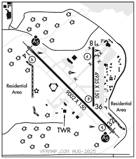
GULFPORT–BILOXI INTL (GPT)(KGPT) P (ANG ARNG) 3 NE UTC–6(–5DT) N30°24.44′
W89°04.21′ 28 B TPA–See Remarks LRA Class I, ARFF Index B NOTAM FILE GPT

RWY 14–32: H9002X150 (ASPH–CONC–GRVD) S–120, D–250, 2S–175, 2D–487, 2D/2D2–1010 PCR 960 R/C/W/T HIRL
RWY 14: MALSR. PAPI(P4R)–GA 3.0° TCH 73′. RVR–T
RWY 32: MALSR. PAPI(P4L)–GA 3.0° TCH 72′. RVR–T
RWY 18–36: H4935X150 (ASPH–GRVD) S–120, D–232, 2D–394, 2D/2D2–923 PCR 580 F/B/X/T MIRL
RWY 18: PAPI(P4R)–GA 3.0° TCH 50′.
RWY 36: PAPI(P4L)–GA 3.0° TCH 50′.
ARRESTING GEAR/SYSTEM
RWY 14 BAK–14 BAK–12B(B) (1800 FT). BAK–14 BAK–12B(B) (1300 FT).RWY 32
SERVICE: S4 FUEL 100LL, JET A, A+ OX 3, 4 LGT When ATCT clsd actvt MALSR Rwy 14 and 32; HIRL Rwy 14–32; MIRL Rwy 18–36–CTAF. MIRL Rwy 18–36 not avbl when ATCT clsd and Rwy 14–32 actv. MILITARY– A–GEAR Avbl drg ANG OPS with 30 min PPR.
JASU 6(A/M32A–86) 3(AM32A–60A) FUEL A+ (MIL) A (C228–701–0400). OIL O–128–133–148(Mil) TRAN ALERT Svc avbl prior coord.
AIRPORT REMARKS: Attended continuously. Rwy end 14 first 2000 ft conc; Rwy end 32 first 1500 ft conc. 150 ft AGL crane 4600 ft N of Rwy 18 thld. Numerous low flying fish spotter acft opr near shoreline between Pascagoula and Gulfport SR–SS. Maverick pad apn area on N end of Twy C rstd to mil acft use only. TPA– 800 ft AGL lgt sngl–eng, 1200 ft AGL conventional, 1500 ft AGL jets. Acft over 115000 lbs are rstrd fm 180 deg turns on Rwy 18–36. Acft with wingspan gtr than 223 ft are rstrd fm oprg on Twy C btn Twy A and AER 32. Civ acft with wingspan of 132 ft or gtr and all acr acft must be escorted alg Twy A N of Twy C by gnd handling agent. Acft operg as sked or chtr pax svc shall not tax on Twy A N of Twy B int wo escort fm gnd handling agent or arpt auth. Acft over 155000 lbs are rstrd fm using the N part of Twy A at Rwy 18–36. Acft over 316000 lbs are rstrd fm using the S part of Twy A between Twy C and Rwy 14–32. Due to apn actvty acft with wingspan gtr than 170 ft should be alert on Twy A btn Twy C and Twy B. Txl F20 btn FBO and Txl G clsd to acft with wingspan gtr than 49 ft. Pole adj txl F20 not lgtd. Rwy 18–36 not avbl for skedd acr ops with more than 9 pax seats or unsked acr ops with at least 31 pax seats.
MILITARY REMARKS:RSTD Military acft or acft supporting a mil mission with wingspan of 132 ft or gtr must have escort or coord tax procs with gnd handling agent prior to tax on Twy A. Power check pad between Rwy 18–36 and Twy A rstd to military acft only. C–5 acft prkg rstd to 1 acft at a time due to twy wid unless coordd. Prkg rstd wi 100 ft LOX fac lctd NE corner apn 1. CAUTION BASH Phase I bird act May–Sep. BASH Phase II in effect Apr–May and Aug–Oct. Ctc Afld Mgmt, for current Bird Watch Cond. CSTMS/AG/IMG CUST and IMG 48 hr PPR. ANG No COMSEC stor. CRTC Afld Mgmt Ops opr 1300–2130Z‡ Mon; 1300–2230Z‡ Tues–Fri and Unit Trng Assembly (UTA) wknds, normally first wknd of month; clsd hol. 48 hr pn PPR rqr ctc CRTC AM ops. Ctc guard ops 15 min prior to arr 377.800. DSN 363–6027; C228–214–6027; fax DSN 363–6031; C228–214–6031. Ltd svc avbl, space A psnl, no pax trml. ARNG MSAVCRAD ops opr 1300–2130Z‡ Mon; 1300–2230Z‡ Tue–Fri and unit trng assembly (UTA) wknd. PPR rqr ctc ARNG Ops, DSN 293–1378/1312, C228–214–1378/1312. Acft inbd to ARNG Ramp ctc Blackjack Ops (241.041.6) 10 min prior to ldg for prk instr.
AIRPORT MANAGER: 228-863-5951
WEATHER DATA SOURCES: ASOS 119.45 (228) 867–9937. LAWRS.
COMMUNICATIONS: CTAF 123.7 ATIS 119.45 UNICOM 122.95
RCO 122.1R 109.0T (GREENWOOD RADIO)
®GULFPORT APP/DEP CON 124.6 (130°–309°) 127.5 (310°–129°) (1200–0500Z‡)
®HOUSTON CENTER APP/DEP CON 127.65 (0500–1200Z‡)
TOWER 123.7 (1200–0500Z‡) GND CON 120.4
AIRSPACE: CLASS D svc 1200–0500Z‡; other times CLASS G.
TRSA svc ctc APP CON
RADIO AIDS TO NAVIGATION: NOTAM FILE GPT.
(L) (L) VORTAC 109.0 GPT Chan 27 N30°24.41′ W89°04.61′ at fld. 25/2E.
TACAN AZIMUTH unusable:
195°–217°
266°–275° byd 12 NM
VOR unusable:
035°–086° blo 5,000′
293°–303°
BAYOU NDB (LOMW) 360 GP N30°29.14′ W89°09.74′ 136° 6.7 NM to fld. 83/2W.
NDB unusable:
085°–270° byd 10 NM
ILS 110.9 I–GPT Rwy 14. Class IIE. LOM BAYOU NDB. Unmonitored when ATCT clsd. Glideslope unusable byd 7° right of course.
ILS 108.3 I–UXI Rwy 32. Class IT. Unmonitored when ATCT clsd.
ASR (1200-0500Z‡)