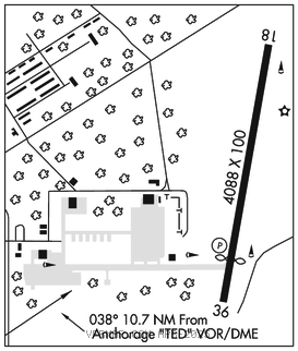
BRYANT AAF (FRN)(PAFR) ARNG 5 NE UTC–9(–8DT) N61°15.95′ W149°39.20′
387 B TPA–See Remarks NOTAM FILE PAFR Not insp.

RWY 18–36: H4088X100 (ASPH) S–38, D–54 PCN 66 F/A/W/T MIRL 0.5% up North
RWY 36: PAPI(P4L)–GA 3.5° TCH 27′. Thld dsplcd 670′. P–line.
RUNWAY DECLARED DISTANCE INFORMATION
RWY 18: TORA–4088 TODA–4088 ASDA–4088 LDA–4088
RWY 36: TORA–4088 TODA–4088 ASDA–4088 LDA–3418
SERVICE: LGT Rwy 36 PAPI does not provide OBST clearance beyond 2 NM from thld, due to mountainous terrain east of cntlrn.
MILITARY REMARKS: Attended Mon–Fri 1630–0230Z‡ exc hols. Wildlife occasionally on or near rwy. Recommend visual inspection of rwy. Visually inspect rwy when twr isclosed. Army Aviation Support Facility C907–428–6333. 96 hr PPR for svcs. Lgtd 180′ antennas at National Guard Armory East of Rwy 18–36. TPA Rwy 18–36 tfc pat R/W 1100′ MSL; fixed wing 1900′ MSL. Tfc pattern for Rwy 18–36 west tfc only. Bryant Twr–907–428–6850, during operating hours.
AIRPORT MANAGER: 907-428-6561
WEATHER DATA SOURCES: ASOS 134.25.
COMMUNICATIONS: CTAF 125.0 ATIS 134.25
®ANCHORAGE APP/DEP CON 290.5 118.6
TOWER 125.0 254.35 (1500–0700Z‡ Mon–Fri except fed hols)
GND CON 121.25 239.25 CLNC DEL 119.1 363.2
PMSV METRO 346.6 AASF OPS 40.8
AIRSPACE: CLASS D svc Mon–Fri 1500–0700Z‡ except fed hols or as NOTAM; other times CLASS G.
RADIO AIDS TO NAVIGATION: NOTAM FILE ANC.
ANCHORAGE (H) (H) VORW/DME 113.15 TED Chan 78(Y) N61°10.07′ W149°57.61′ 038° 10.7 NM to fld. 92/18E.
VOR unusable:
041°–091° byd 25 NM blo 15,000′
091°–096° byd 20 NM blo 15,000′
096°–121° byd 25 NM blo 12,500′
121°–146° byd 25 NM blo 9,000′
DME unusable:
041°–091° byd 25 NM blo 15,000′
091°–096° byd 20 NM blo 15,000′
096°–121° byd 25 NM blo 12,500′
121°–146° byd 25 NM blo 9,000′
196°–206° byd 25 NM blo 3,500′
206°–211° byd 25 NM blo 4,000′
211°–221° byd 25 NM blo 3,500′
COMM/NAV/WEATHER REMARKS: For a toll free call to Kenai FSS dial 1–866–864–1737. Bryant twr –907–428–6850 (during operating hours).