SHERMAN AAF (FLV)(KFLV) MIL/CIV A 3 N UTC–6(–5DT) N39°22.05′ W94°54.86′
771 B TPA–See Remarks NOTAM FILE ICT
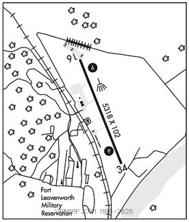
RWY 16–34: H5318X102 (ASPH–CONC–GRVD) PCN 31 F/C/W/T HIRL
RWY 16: PAPI(P4L)–GA 3.0° TCH 40′. Berm.
RWY 34: PAPI(P4L)–GA 3.0° TCH 41′. Road. Rgt tfc.
RUNWAY DECLARED DISTANCE INFORMATION
RWY 16: TORA–5518 TODA–5518 ASDA–5518 LDA–5318
RWY 34: TORA–5518 TODA–5518 ASDA–5913 LDA–5518
SERVICE: FUEL 100LL, JET A, A1+ LGT ACTIVATE PAPI Rwy 16 and Rwy 34; HIRLRwy 16–34; twy lgts–CTAF. Rotating bcn lctd .5NM NW fr afld. MILITARY–FUEL Jet A only avbl 1330–2230Z‡. 24 hr PPR. Svc otr times for code 4 & abv.
AIRPORT REMARKS: Attended Mon–Fri 1500–0200Z‡. Limited svc after hrs and fed hol. General aviation ramp attended 1500–0000Z‡, call 913–651–0111. Fuel avbl 1500–0200Z‡ and aft hrs by req. Joint use airfield, FBO attended Mon–Fri 1500–0000Z‡. Wildlife on and invof rwy. Numerous migratory birds on and invof arpt Oct–Apr. Calm wind use Rwy 16. +19′ lgtd levee 780′ from AER 16, outbound (private road on top of +9′ levee).
MILITARY REMARKS: Opr Mon–Fri 1330–2230Z‡.Limited svc ot and fed hol.
RSTD Military ramp 24 hour PPR, call DSN 552–6041/39/41 or C913–684–6041/39/41. Nohazardouscargo pad. TFC PAT TPA–Rotary wing acft 1469 (698), turbine fixed wing acft 1799 (1028). MISC Base Ops 1330–2230Z‡ (0730–1630L) Mon–Fri, exc hol, ot code 4 and abv by PPR. Airfield conditions unmonitored and unreported outside of posted operating hours. No TRAN alert, lavatory svc or de–ice capability. All acft with code 4 VIP or abv ctc Sherman Base ops (126.2) at least 20 min prior to ldg. Civilian acft on non–government business use City of Leavenworth ramp Inc C913–651–0111 on south end of fld, Twy C opr 1500–0000Z‡.
AIRPORT MANAGER: 913-684-6040
COMMUNICATIONS: CTAF 126.2
®KANSAS CITY APP/DEP CON 124.7 284.7
CLEARANCE DELIVERY PHONE: For CD ctc Kansas City Apch at 816-329-2710.
RADIO AIDS TO NAVIGATION: NOTAM FILE MCI.
KANSAS CITY (H) (H) VORTACW 113.25 MCI Chan 79(Y) N39°17.12′ W94°44.22′ 296° 9.6 NM to fld. 1017/5E.