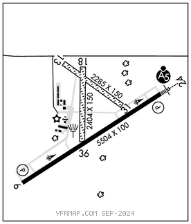
ALBERTUS (FEP)(KFEP) 3 SE UTC–6(–5DT) N42°14.77′ W89°34.92′
859 B TPA—See Remarks NOTAM FILE FEP

RWY 06–24: H5504X100 (ASPH–GRVD) S–20, D–60 MIRL 0.3% up SW
RWY 06: PAPI(P4L)—GA 3.0° TCH 50′. Tree.
RWY 24: MALSR. PAPI(P4L)—GA 3.0° TCH 46′.
RWY 18–36: 2404X150 (TURF)
RWY 13–31: 2285X150 (TURF)
SERVICE: S4 FUEL 100LL, JET A LGT MIRL Rwy 06–24 and twy lgts preset on low ints SS–SR, to incr inst and ACTIVATE MALSR Rwy 24—CTAF. PAPI Rwy 06 and Rwy 24 opr continuously.
AIRPORT REMARKS: Attended Mon–Fri 1400–2300Z‡, Sat 1500–2200Z‡. Fuel: 100LL available 24 hr self service. TPA—1259 (400) ultralights, 1659 (800) piston acft. Rwy 18–36 thlds marked with in–ground conc markers. Rwy 13–31 thlds marked with in–ground conc markers.
AIRPORT MANAGER: 815-232-1078
WEATHER DATA SOURCES: AWOS–3 120.525 (815) 233–4472.
COMMUNICATIONS: CTAF/UNICOM 122.8
®ROCKFORD APP/DEP CON 126.0
CLNC DEL 121.85
CLEARANCE DELIVERY PHONE: For CD ctc Chicago ARTCC at 630-906-8921.
RADIO AIDS TO NAVIGATION: NOTAM FILE JVL.
JANESVILLE (L) (L) VORW/DME 114.3 JVL Chan 90 N42°33.48′ W89°06.32′ 226° 28.3 NM to fld. 932/3E.
VOR unusable:
001°–089°
155°–175° byd 15 NM
282°–000° byd 30 NM blo 3,000′
ILS/DME 108.3 I–PJE Chan 20 Rwy 24. Class IT. Unmonitored.