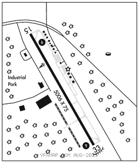
ELIZABETHTOWN
CURTIS L BROWN JR FLD (EYF)(KEYF) 2 SE UTC–5(–4DT) N34°36.11′ W78°34.76′ 131 B NOTAM FILE EYF

RWY 15–33: H5006X75 (ASPH) S–30, D–45 MIRL
RWY 15: REIL. PAPI(P2L)–GA 3.0° TCH 32′. Fence.
RWY 33: REIL. PAPI(P2L)–GA 3.0° TCH 33′. Trees.
SERVICE: S2 FUEL 100LL, JET A1+ LGT Bcn obscured by trees to the east. Actvt REIL Rwy 15 & 33–CTAF. PAPI Rwy 15 & 33 on dawn to 0600Z‡ or when MIRL Rwy 15–33 on. After 0600Z‡ actvt MIRL Rwy 15–33 and twy–CTAF.
AIRPORT REMARKS: Attended 1300–2200Z‡. For svc after hrs and emerg call 910–862–4522. Unatndd Thanksgiving, Christmas and New Years Day. Deer & birds on and invof arpt. Low level mil act invof arpt. Self svc fuel avbl 24 hrs with credit card. 10′ ditch along left side Twy A toward Rwy 33.
AIRPORT MANAGER: 910-862-4522
WEATHER DATA SOURCES: AWOS–3P 119.475 (910) 862–9982.
COMMUNICATIONS: CTAF/UNICOM 122.8
®FAYETTEVILLE APP/DEP CON 133.0
CLEARANCE DELIVERY PHONE: For CD ctc Washington ARTCC at 703-771-3587.
RADIO AIDS TO NAVIGATION: NOTAM FILE FAY.
FAYETTEVILLE (L) (L) VORW/DME 114.85 FAY Chan 95(Y) N34°59.13′ W78°52.50′ 151° 27.2 NM to fld. 187/4W.
VOR unusable:
058°–068° blo 4,000′
090°–100°
DME unusable:
090°–100°