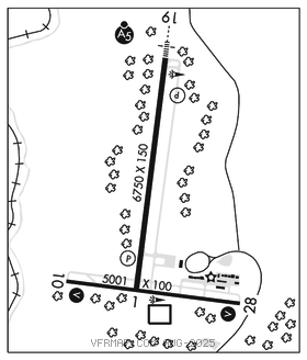
BECKLEY
RALEIGH CO MEML (BKW)(KBKW) 3 E UTC–5(–4DT) N37°47.24′ W81°07.45′ 2504 B ARFF Index–See Remarks NOTAM FILE BKW

RWY 01–19: H6750X150 (ASPH–GRVD) S–75, D–150, 2S–140, 2D–200 PCN 38 F/B/W/U HIRL 0.7% up S
RWY 01: REIL. PAPI(P4L)–GA 3.0° TCH 40′.
RWY 19: MALSR. PAPI(P4L)–GA 3.0° TCH 55′.
RWY 10–28: H5001X100 (ASPH) S–45, D–60 PCN 38 F/B/W/U MIRL 0.3% up E
RWY 10: REIL. VASI(V4R)–GA 3.0° TCH 61′.
RWY 28: REIL. VASI(V4L)–GA 3.75° TCH 66′.
RUNWAY DECLARED DISTANCE INFORMATION
RWY 01: TORA–6750 TODA–6750 ASDA–6750 LDA–6750
RWY 10: TORA–5001 TODA–5001 ASDA–5001 LDA–5001
RWY 19: TORA–6750 TODA–6750 ASDA–6750 LDA–6750
RWY 28: TORA–5001 TODA–5001 ASDA–5001 LDA–5001
SERVICE: S4 FUEL 100LL, JET A LGT Actvt MALSR Rwy 19; REIL Rwy 01, 10, and 28; VASI Rwy 10 and 28; MIRL Rwy 10–28; HIRL Rwy 01–19; twy lgts–CTAF. PAPI Rwy 01 and 19 set at medium, ctc UNICOM to change intst.
AIRPORT REMARKS: Attended continuously. Deer, birds and wild turkeys on and invof arpt. All sfcs work in prog, grass cutting Apr thru Oct. Class I, ARFF Index B. PPR 24 hrs for unsked acr opns with more than 30 psgr seats; call amgr 304–255–0476. Index B coverage is prvdd.
AIRPORT MANAGER: 304-255-0476
WEATHER DATA SOURCES: ASOS 121.55 (304) 362–0292.
COMMUNICATIONS: CTAF/UNICOM 123.0
®CHARLESTON APP/DEP CON 125.4
AIRSPACE: CLASS E.
RADIO AIDS TO NAVIGATION: NOTAM FILE BKW.
BECKLEY (DH) DME 117.7 BKW Chan 124 N37°46.82′ W81°07.41′ at fld. 2517.
DME unusable:
080°–215° byd 15 NM
ILS 111.7 I–MQU Rwy 19. Class IB.