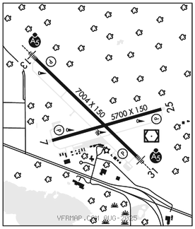
BEMIDJI RGNL (BJI)(KBJI) 3 NW UTC–6(–5DT) N47°30.64′ W94°56.08′
1391 B ARFF Index–See Remarks NOTAM FILE BJI

RWY 13–31: H7004X150 (ASPH–GRVD) S–75, D–200 PCN 11 F/B/Y/U HIRL
RWY 13: MALSR. PAPI(P4L)–GA 3.0° TCH 45′. Trees.
RWY 31: MALSR. PAPI(P4L)–GA 3.0° TCH 45′.
RWY 07–25: H5700X150 (ASPH–GRVD) S–75, D–200 PCN 11 F/B/Y/U MIRL
RWY 07: REIL. PAPI(P4L)–GA 3.0° TCH 44′.
RWY 25: REIL. PAPI(P4L)–GA 3.0° TCH 47′. Trees.
RUNWAY DECLARED DISTANCE INFORMATION
RWY 07: TORA–5700 TODA–5700 ASDA–5700 LDA–5700
RWY 13: TORA–7002 TODA–7002 ASDA–7002 LDA–7002
RWY 25: TORA–5700 TODA–5700 ASDA–5700 LDA–5700
RWY 31: TORA–7002 TODA–7002 ASDA–7002 LDA–7002
SERVICE: S4 FUEL 100LL, JET A OX 3, 4 LGT HIRL Rwy 13–31 preset on low ints, to incr ints and ACTIVATE REIL Rwy 07–25; MIRL Rwy 07–25; MALSR Rwy 13 and Rwy 31, HIRL Rwy 13–31–CTAF. PAPI Rwy 07, Rwy 25, Rwy 13 and Rwy 31 opr continuously.
AIRPORT REMARKS: Attended Mon 1300–0300Z‡, Tue–Fri 1200–0300Z‡, Sat–Sun 1400–2300Z‡. Deer and birds on and invof arpt. Snow removal crews monitor CTAF during all air carrier operations for airfield cond info. ARFF crews monitor CTAF during all air carrier operations. Class I ARFF Index A, 48 hr PPR for unscheduled air carrier ops with more than 30 passenger seats, call arpt manager 218–444–2438.
AIRPORT MANAGER: 218-558-5190
WEATHER DATA SOURCES: AWOS–3 119.275 (218) 755–2575.
COMMUNICATIONS: CTAF/UNICOM 122.8
RCO 122.3 (PRINCETON RADIO)
®MINNEAPOLIS CENTER APP/DEP CON 134.75
CLEARANCE DELIVERY PHONE: For CD if una to ctc on FSS freq, ctc Minneapolis ARTCC at 651-463-5588.
AIRSPACE: CLASS E svc 1045–0545Z‡ Mon–Sat, 1400–0545Z‡ Sun; other times CLASS G.
RADIO AIDS TO NAVIGATION: NOTAM FILE BJI.
LAKE BEMIDJI (T) (T) VORW/DME 110.0 IDJ Chan 37 N47°30.46′ W94°55.40′ at fld. 1384/1E.
ILS/DME 109.35 I–BJI Chan 30(Y) Rwy 25. Class IA. Unmonitored.
ILS 111.9 I–MDI Rwy 31. Class IE. Glideslope unusable for cpd apch blw 2,126′ MSL.