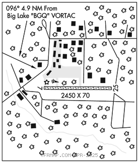
BIG LAKE (BGQ)(PAGQ) 1 SE UTC–9(–8DT) N61°32.08′ W149°48.75′
162 B NOTAM FILE ENA

RWY 07–25: 2450X70 (GRVL) MIRL
RWY 07: Trees.
RWY 25: Trees.
SERVICE: S4 LGT ACTIVATE MIRL Rwy 07–25–122.8.
AIRPORT REMARKS: Unattended. Rwy soft on both ends. Rwy cond not monitored recommend visual inspection prior to use. Be alert: Occasional ultra–light tfc. Be alert: Frost heave on rwy approximately 2200′. 190′ AGL lgtd twr 2 NM NE of arpt. Low flying aircraft in vcnty of approach to Big Lake VOR. Updraft off of rising hill on apch to Rwy 25. Rwy 07 +15′ road parallel to rwy end. Arpt has designated transient acft parking avbl. Transient acft parking is designated with green cones.
AIRPORT MANAGER: 907-745-2159
COMMUNICATIONS: CTAF 122.8
®ANCHORAGE APP/DEP CON 118.6
RADIO AIDS TO NAVIGATION: NOTAM FILE ENA.
(H) (H) VORTACW 112.5 BGQ Chan 72 N61°34.17′ W149°58.03′ 096° 4.9 NM to fld. 179/19E.
TACAN AZIMUTH unusable:
230°–245° byd 38 blo 8,000′
DME unusable:
230°–245° byd 38 blo 8,000′
COMM/NAV/WEATHER REMARKS: For a toll free call to Kenai FSS dial 1–866–864–1737.