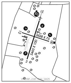
ALTOONA/BLAIR CO (AOO)(KAOO) 12 S UTC–5(–4DT) N40°17.78′ W78°19.20′
1503 B Class II, ARFF Index A NOTAM FILE AOO

RWY 03–21: H5465X100 (ASPH–GRVD) S–16, D–44 PCN 13 F/B/X/T HIRL 0.6% up S
RWY 03: REIL. PAPI(P4L)–GA 3.0° TCH 43′. Trees.
RWY 21: MALSR. PAPI(P4L)–GA 3.0° TCH 52′. Trees.
RWY 12–30: H3668X75 (ASPH) S–11.5, D–33 PCN 11 F/B/X/T MIRL
RWY 12: REIL. PAPI(P4L)–GA 3.0° TCH 54′. Trees.
RWY 30: REIL. PAPI(P4R)–GA 4.0° TCH 54′. Tree.
RUNWAY DECLARED DISTANCE INFORMATION
RWY 03: TORA–5465 TODA–5465 ASDA–5465 LDA–5465
RWY 12: TORA–3668 TODA–3668 ASDA–3668 LDA–3668
RWY 21: TORA–5465 TODA–5465 ASDA–5465 LDA–5465
RWY 30: TORA–3668 TODA–3668 ASDA–3668 LDA–3668
SERVICE: S4 FUEL 100LL, JET A OX 1, 3 LGT Rwy 03–21, thld lgts and edge lgts OTS exc with PCL, avbl fm 0100–1300Z‡ daily. Rwy 12–30, thld lgts and edge lgts OTS exc with PCL avbl fm 0100–1300Z‡ daily. HIRL Rwy 03–21 and MIRL Rwy 12–30 preset low intst, incr intst and ACTVT PAPI Rwy 12, 30, 03 and 21, MALSR Rwy 21 and REIL Rwy 03, 12 and 30–CTAF.
NOISE: Preferred rwy is Rwy 21; for noise abatement when departing Rwy 03, maintain rwy heading until 2 NM north of arpt.
AIRPORT REMARKS: Attended Mon–Fri 0930–0330Z‡, Sat 1230–0030Z‡, Sun 1330–0130Z‡. Rwy/twy conds unmonitored outside of normal attendance hrs. Specialized acft (ultralgt, homebuilt, etc) ctc amgr 814–793–2027 or UNICOM prior to ldg. PPR 24 hrs for unscheduled air carrier and non–air carrier ops with more than 30 passenger seats call arpt manager 814–793–2027. Excp for taxi, Rwy 12–30 not avbl for sked acr opns with more than 9 pax and unsked for acr opns with more than 30 pax.
AIRPORT MANAGER: 814-793-2027
WEATHER DATA SOURCES: ASOS 127.125 (814) 793–9655.
COMMUNICATIONS: CTAF 123.6
RCO 122.2 (ALTOONA RADIO)
®JOHNSTOWN APP/DEP CON 121.2 (1200–0400Z‡)
®CLEVELAND CENTER APP/DEP CON 124.4 (0400–1200Z‡)
CLEARANCE DELIVERY PHONE: For CD ctc Johnstown Apch at 814-532-5960, when Apch clsd ctc Cleveland ARTCC at 440-774-0213.
AIRSPACE: CLASS E.
RADIO AIDS TO NAVIGATION: NOTAM FILE AOO.
ST THOMAS (L) TACAN Chan 97 THS (115.0) N39°55.99′ W77°57.06′ 329° 27.6 NM to fld. 2338/7W.
ILS 111.1 I–AOO Rwy 21. Class IA. LOC unusable byd 25° right of course.