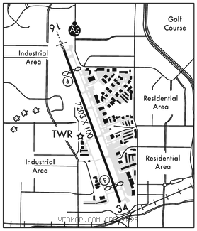
DALLAS
ADDISON (ADS)(KADS) 9 N UTC–6(–5DT) N32°58.11′ W96°50.19′ 645 B TPA–See Remarks NOTAM FILE ADS

RWY 16–34: H7203X100 (ASPH–GRVD) S–60, D–120 HIRL
RWY 16: MALSR. PAPI(P4R)–GA 3.0° TCH 51′. Thld dsplcd 979′. Road.
RWY 34: REIL. PAPI(P4L)–GA 3.0° TCH 60′. Thld dsplcd 772′. Road.
RUNWAY DECLARED DISTANCE INFORMATION
RWY 16: TORA–7203 TODA–7203 ASDA–7203 LDA–6224
RWY 34: TORA–7203 TODA–7203 ASDA–7203 LDA–6431
ARRESTING GEAR/SYSTEM
RWY 16: EMAS
SERVICE: S4 FUEL 100LL, JET A OX 2, 3 LGT ACTVT MALSR Rwy 16; HIRL Rwy 16–34–CTAF.
NOISE: Noise sensitive areas surround arpt. Pilots req to use NBAA std noise procedures.
AIRPORT REMARKS: Attended 1200–0400Z‡. Birds on and invof arpt. No touch and go ldgs without arpt mgr apvl. Numerous 200 ft bldgs within 1 mile east and south of arpt, transmission twrs and water tanks west of arpt. TPA–1601 (956) for light acft, 2001 (1356) for large acft. Be alert: rwy hldg ptn mrkgs lctd at the west edge of Twy A. User Fee arpt. CPB ofc hrs M–F 1600–0300Z‡. 214–208–3636. Flight Notification Service (ADCUS) available.
AIRPORT MANAGER: 972-392-4850
WEATHER DATA SOURCES: AWOS–3PT (972) 386–4855 LAWRS.
COMMUNICATIONS: CTAF 126.0 ATIS 133.4 972–628–2439 UNICOM 122.95
®LONE STAR APP/DEP CON 124.3
TOWER 126.0 (1200–0400Z‡) GND CON 121.6 CLNC DEL 119.55
AIRSPACE: CLASS D svc 1200–0400Z‡; other times CLASS G.
RADIO AIDS TO NAVIGATION: NOTAM FILE FTW.
MAVERICK (VH) (H) VORW/DME 113.1 TTT Chan 78 N32°52.15′ W97°02.43′ 054° 11.9 NM to fld. 536/6E. All acft arriving DFW are requested to turn DME off until departure due to traffic overload of Maverick DME
DME unusable:
180°–190° byd 10 NM
240°–260° byd 20 NM blo 3,500′
VOR unusable:
105°–110° byd 40 NM
ILS/DME 110.1 I–ADS Chan 38 Rwy 16. Class IT. Unmonitored when ATCT closed. DME also serves Rwy 34.
ILS/DME 110.1 I–TBQ Chan 38 Rwy 34. Class IB. Localizer unmonitored when ATCT closed. DME also serves Rwy 16.
COMM/NAV/WEATHER REMARKS: AWOS–3 info only avbl when ATCT clsd. ATIS avbl during twr hrs.