STOW
MINUTE MAN AIR FLD (6B6) 2 N UTC–5(–4DT) N42°27.62′ W71°31.08′ 280 B TPA–See Remarks NOTAM FILE BDR

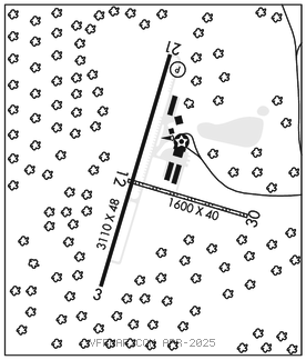
RWY 03–21: H3110X48 (ASPH) S–12.5 LIRL
RWY 03: Trees.
RWY 21: REIL. PAPI(P2L)–GA 3.5° TCH 24′. Trees.
RWY 12–30: 1600X40 (TURF) 0.3% up NW
RWY 12: Trees.
RWY 30: Trees.
SERVICE: S4 FUEL 100LL LGT ACTVT REIL Rwy 21–CTAF.
NOISE: Noise abatement procedures in effect notify arpt manager 978–897–3933 of intention to opr between 0400–1100Z‡.
AIRPORTREMARKS: Attended 1400–2100Z‡. Before using Rwy 12–30 call arpt mgr to determine rwy conds. Tree obstruction in apch, primary and transition surfaces Rwy 03 and Rwy 12–30. TPA–for light acft 1032′ AGL.
AIRPORT MANAGER: 978-897-3933
COMMUNICATIONS: CTAF/UNICOM 122.8
®BOSTON APP/DEP CON 124.4 Clnc del thru Bridgeport Radio (BDR) 1–866–293–5149.
CLEARANCE DELIVERY PHONE: For CD ctc Boston Apch at 603-594-5552.
RADIO AIDS TO NAVIGATION: NOTAM FILE MHT.
MANCHESTER (L) DME 114.4 MHT Chan 91 N42°52.11′ W71°22.17′ 195° 25.3 NM to fld. 470.