TYLER POUNDS RGNL (TYR)(KTYR) 3 W UTC–6(–5DT) N32°21.21′ W95°24.18′
544 B Class I, ARFF Index B NOTAM FILE TYR
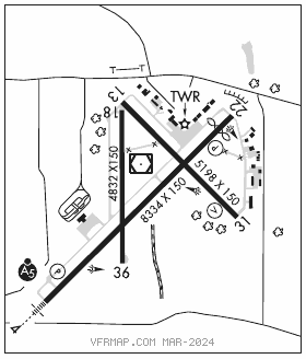
RWY 04–22: H8334X150 (CONC–GRVD) S–120, D–222, 2S–84, 2T–223, 2D–357, 2D/D1–212, C5–342 PCN 68 R/C/W/T HIRL
RWY 04: MALSR. PAPI(P4L)—GA 3.0° TCH 55′.
RWY 22: REIL. PAPI(P4L)—GA 3.0° TCH 54′. Thld dsplcd 600′. Tree.
RWY 13–31: H5198X150 (ASPH–GRVD) S–25, D–40 PCN 9 F/C/X/T HIRL 0.5% up SE
RWY 13: Pole.
RWY 31: VASI(V4L)—GA 3.0° TCH 54′. Road.
RWY 18–36: H4832X150 (ASPH–GRVD) S–109, D–172, 2D–289 PCN 43 F/B/X/T MIRL 0.6% up S
RWY 18: Tree.
RWY 36: Tree.
RUNWAY DECLARED DISTANCE INFORMATION
RWY 04: TORA–8334 TODA–8334 ASDA–7734 LDA–7734
RWY 13: TORA–5198 TODA–5198 ASDA–5198 LDA–5198
RWY 18: TORA–4832 TODA–4832 ASDA–4832 LDA–4832
RWY 22: TORA–8334 TODA–8334 ASDA–8334 LDA–7734
RWY 31: TORA–5198 TODA–5198 ASDA–5198 LDA–5198
RWY 36: TORA–4832 TODA–4832 ASDA–4832 LDA–4832
SERVICE: S4 FUEL 100LL, JET A OX 1, 3 LGT When ATCT clsd actvt MALSR Rwy 04; REIL Rwy 22; HIRL Rwy 04–22; MIRL Rwy 18–36; twy lgts—CTAF. HIRL Rwy 13–31 preset med intst, to incr intst actvt—CTAF. PAPI Rwy 04 and 22, VASI Rwy 31 opr consly. Rwy 22 VGSI unusbl byd 9 deg left and right of cntrln.
NOISE: Noise abatement procedures in effect Call 903–590–3048.
AIRPORT REMARKS: Attended 1100–0400Z‡. West side passenger terminal ramp access rstd to air carrier. Conditions not monitored btn the hrs of 9:30 PM and 6:30 AM local.
AIRPORT MANAGER: 903-531-2343
WEATHER DATA SOURCES: ASOS (903) 535–9105 LAWRS.
COMMUNICATIONS: CTAF 120.1 ATIS 126.25 UNICOM 122.95
RCO 122.3 (FORT WORTH RADIO)
®LONGVIEW APP/DEP CON 128.75 (1200–0400Z‡)
®FORT WORTH CENTER APP/DEP CON 135.25 (0400–1200Z‡)
TOWER 120.1 (1230–0330Z‡) GND CON 121.9
CLEARANCE DELIVERY PHONE: For CD if una to ctc on FSS freq, ctc Fort Worth ARTCC at 817-858-7584.
AIRSPACE: CLASS D svc 1230–0330Z‡; other times CLASS G.
RADIO AIDS TO NAVIGATION: NOTAM FILE TYR.
(T) (T) VORW/DME 114.2 TYR Chan 89 N32°21.35′ W95°24.21′ at fld. 537/6E.
DME unusable:
062°–092° byd 35 NM blo 2,200′
ILS/DME 111.95 I–TYR Chan 56(Y) Rwy 04. Class IE. Unmonitored when ATCT clsd. DME unusable byd 20° left of course.
COMM/NAV/WEATHER REMARKS: Helicopters operating inbound or outbound to/from the downtown hospitals state intention on 123.075.