COMANCHE CO–CITY (MKN)(KMKN) 2 NE UTC–6(–5DT) N31°55.22′ W98°35.95′
1387 B NOTAM FILE MKN
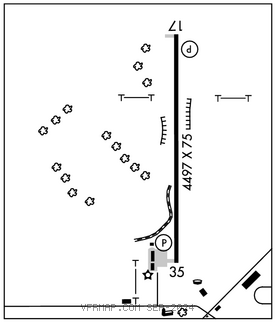
RWY 17–35: H4497X75 (ASPH) S–12.5 MIRL 0.3% up N
RWY 17: PAPI(P2L)–GA 4.0° TCH 40′.
RWY 35: PAPI(P2L)–GA 4.0° TCH 39′. Tree. Rgt tfc.
SERVICE: FUEL 100LL, JET A LGT Dusk–Dawn. MIRL Rwy 17–35 preset low intst; to incr intst actvt–CTAF.
AIRPORTREMARKS:Unattended. 100LL self svc fuel. Deer and wildlife on and invof arpt.
AIRPORT MANAGER: 325-330-0289
WEATHER DATA SOURCES: AWOS–3 118.575 (325) 356–7032.
COMMUNICATIONS: CTAF/UNICOM 123.075
®FORT WORTH CENTER APP/DEP CON 127.15
CLEARANCEDELIVERY PHONE: For CD ctc Fort Worth ARTCC at 817-858-7584.
RADIO AIDS TO NAVIGATION: NOTAM FILE SJT.
GOOCH SPRINGS (H) (H) VORTACW 112.5 AGJ Chan 72 N31°11.13′ W98°08.51′ 327° 49.9 NM to fld. 1191/5E.