CALDWELL
ESSEX CO (CDW)(KCDW) 2 N UTC–5(–4DT) N40°52.51′ W74°16.88′ 172 B TPA–See Remarks NOTAM FILE CDW

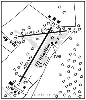
RWY 04–22: H4552X80 (ASPH–GRVD) S–30 HIRL
RWY 04: Thld dsplcd 375′. Tree.
RWY 22: REIL. PAPI(P4R)–GA 3.0° TCH 42′. Thld dsplcd 135′. Trees. Rgt tfc.
RWY 10–28: H3719X75 (ASPH) S–30 MIRL
RWY 10: Thld dsplcd 344′. Tree.
RWY 28: Thld dsplcd 550′. Tree. Rgt tfc.
RUNWAY DECLARED DISTANCE INFORMATION
RWY 04: TORA–4552 TODA–4552 ASDA–4351 LDA–3977
RWY 10: TORA–3719 TODA–3719 ASDA–3519 LDA–2822
RWY 22: TORA–4552 TODA–4552 ASDA–4436 LDA–4042
RWY 28: TORA–3719 TODA–3719 ASDA–3438 LDA–2822
SERVICE: S4 FUEL 100LL, JET A OX 4 LGT When ATCT clsd, PAPI Rwy 22; HIRL 04–22; MIRL Rwy 10–28 opr consly. HIRL Rwy 04–22; MIRL Rwy 10–28 preset to low intst. To incrs intst and actvt REIL Rwy 22–CTAF. Rwy 22 PAPI unusable byd 5° right of centerline due to obstruction.
NOISE: Non–standard traffic patterns for Rwy 04 prohibited due to noise sensitive area southwest of the airport.
AIRPORT REMARKS: Attended 1200–0400Z‡. Local ops suspended Mon–Sat 0400–1200Z‡ and 0400Z‡ Sat–1500Z‡ Sun. Deer and birds on and invof arpt. Touch and go ldgs ltd to based acft only. TPA for large and turbojet acft 1699(1527), light acft 1199(1027). Fixed wing VFR acft dep: Rwy 04–fly rwy hdg for 1 mi, then turn crosswind if remaining in the tfc pat. If departing the tfc pat, cont on rwy hdg til reaching tfc pat alt. Fixed wing VFR acft dep: Rwy 10–fly hdg 080 deg at rwy dep end. Upon reaching 900 ft MSL, turn crosswind if remaining in the tfc pat; if departing the tfc pat, cont on hdg 080 deg til reaching tfc pat alt. Fixed wing VFR acft dep: Rwy 22 fly rwy hdg til reaching 900 ft MSL then turn crosswind if remaining in the tfc pat. If departing the tfc pat, cont on rwy hdg til reaching tfc pat alt. Fixed wing VFR acft dep: Rwy 28 fly rwy hdg for 1 mi then turn crosswind if remaining in the tfc pat. If departing the tfc pat, cont on rwy hdg til reaching tfc pat alt. Rotocraft: If psbl, cross the arpt bdry at or abv 700 ft MSL. Pilots be alert–the Morristown ILS and GPS Rwy 23 approaches transit Essex Co Arpt Class D asp. Tfc passes two mi west of the arpt descending through 2000 ft MSL. Eng run–ups on Twy N at AER 28 shd be conducted to lmt efct to acft parked on RN Ramp. Ldg fee for all tran acft. NOTE: See Special Notices–Arrival Alert.
AIRPORT MANAGER: 973-227-4567
WEATHER DATA SOURCES: ASOS 135.5 (973) 575–4417.
COMMUNICATIONS: CTAF 119.8 ATIS 135.5 UNICOM 122.95
®NEWARK APP CON 127.6
CALDWELL TOWER 119.8 (1200–0400Z‡) GND CON 121.9 CLNC DEL 121.1
®NEWARK DEP CON 119.2
CLEARANCE DELIVERY PHONE: For CD when ATCT is clsd ctc Newark Apch at 800-645-3206.
AIRSPACE: CLASS D svc 1200–0400Z‡; other times CLASS G.
RADIO AIDS TO NAVIGATION: NOTAM FILE TEB.
TETERBORO (T) (T) VORW/DME 108.4 TEB Chan 21 N40°50.92′ W74°03.73′ 290° 10.1 NM to fld. 8/11W.
DME unusable:
060°–080° byd 22 NM blo 2,500′
081°–120° blo 4,000′
121°–180° blo 3,000′
236°–246°
VOR unusable:
081°–120° blo 4,000′
121°–180° blo 3,000′
236°–246°
LOC 109.35 I–CDW Rwy 22.
COMM/NAV/WEATHER REMARKS: Emerg frequency 121.5 not avbl at twr.