AUGUSTA
AUGUSTA RGNL AT BUSH FLD (AGS)(KAGS) 6 S UTC–5(–4DT) N33°22.20′ W81°57.87′ 146 B ARFF Index–See Remarks NOTAM FILE AGS MON Airport
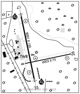
RWY 17–35: H8001X150 (CONC–GRVD) S–155, D–160, 2S–175, 2D–450, 2D/2D2–975 PCR 930 R/B/W/T HIRL
RWY 17: MALSR. PAPI(P4L)–GA 3.0° TCH 71′. RVR–TR Tree.
RWY 35: MALSR. PAPI(P4L)–GA 3.0° TCH 72′. RVR–TR Trees.
RWY 08–26: H6001X100 (ASPH–GRVD) S–52, D–71, 2S–90, 2D–126 PCR 120 F/B/X/T MIRL
RWY 08: REIL. PAPI(P4L)–GA 3.0° TCH 55′. Trees.
RWY 26: REIL. PAPI(P4L)–GA 3.0° TCH 55′. Trees.
SERVICE: S4 FUEL 100LL, JET A OX1, 2, 3, 4 LGT PAPI Rwy 08–26 and Rwy 17–35 oper consly. REIL Rwy 08 and Rwy 26, MIRL Rwy 08–26, HIRL Rwy 17–35 oper consly when twr clsd. ACTVT MALSR Rwy 17 and Rwy 35–CTAF.
AIRPORT REMARKS: Attended continuously. Birds on and invof arpt, heavy bird activity invof arpt Nov–Mar. Caution–wildlife hazard coyote. Class I, ARFF Index B. Index C avbl upon req. Taxilane ramp entrance/exit point into std aero storm water ditch on north side.
AIRPORT MANAGER: 706-798-3236
WEATHER DATA SOURCES: ASOS (706) 250–6089 LLWAS.
COMMUNICATIONS: CTAF 118.7 ATIS 132.75 UNICOM 122.95
®APP/DEP CON 119.15 (350°–169°) 126.8 (170°–349°) (1145–0400Z‡)
®ATLANTA CENTER APP/DEP CON 128.1 (0400–1145Z‡)
TOWER 118.7 (1145–0400Z‡) GND CON 121.9 CLNC DEL 118.65
CLEARANCEDELIVERY PHONE: For CD if una to ctc on FSS freq, ctc Augusta Apch at 706-771-1777, when Apch clsd ctc Atlanta ARTCC at 770-210-7692.
AIRSPACE: CLASS D svc 1145–0400Z‡; other times CLASS E.
TRSA svc ctc APP CON
RADIO AIDS TO NAVIGATION: NOTAM FILE AND.
COLLIERS (VH) (H) VORTAC 113.9 IRQ Chan 86 N33°42.44′ W82°09.72′ 158° 22.5 NM to fld. 4204W.
EMORY NDB (HW) 385 EMR N33°27.77′ W81°59.81′ 168° 5.8 NM to fld. 161/4W. NOTAM FILE MCN. NDB unmonitored when Augusta ATCT closed.
BUSHE NDB (LOMW) 233 AG N33°17.21′ W81°56.81′ 354° 5.1 NM to fld. 301/4W. NOTAM FILE AGS.
ILS 111.75 I–MZX Rwy 17. Class IA. Unmonitored when ATCT clsd.
ILS 110.5 I–AGS Rwy 35. Class IB. LOM BUSHE NDB. Unmonitored when ATCT clsd. Autopilot cpd apch NA blw 940′.
ASR (1145–0400Z‡)