LUBBOCK PRESTON SMITH INTL (LBB)(KLBB) 4 N UTC–6(–5DT) N33°39.82′ W101°49.23′
3282 B LRA Class I, ARFF Index C NOTAM FILE LBB MON Airport
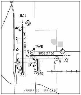
RWY 17R–35L: H11500X150 (CONC–GRVD) S–100, D–170, 2S–175, 2D–350 PCN 65 R/B/W/T HIRL
RWY 17R: MALSR. PAPI(P4R)—GA 3.0° TCH 69′. RVR–T Rgt tfc. 0.4% down.
RWY 35L: VASI(V4L)—GA 3.0° TCH 54′. RVR–R 0.3% up.
RWY 08–26: H8003X150 (CONC–GRVD) S–100, D–170, 2S–175, 2D–350 PCN 71 R/B/W/T HIRL
RWY 08: REIL. PAPI(P4L)—GA 3.0° TCH 50′. RVR–R Rgt tfc.
RWY 26: MALSR. PAPI(P4L)—GA 3.0° TCH 50′. RVR–T
RWY 17L–35R: H2891X74 (ASPH) S–12.5
RWY 35R: Road. Rgt tfc.
RUNWAY DECLARED DISTANCE INFORMATION
RWY 08: TORA–8003 TODA–8003 ASDA–8003 LDA–8003
RWY 17L:TORA–2891 TODA–2891 ASDA–2891 LDA–2891
RWY 17R:TORA–11500TODA–11500 ASDA–11500 LDA–11500
RWY 26: TORA–8003 TODA–8003 ASDA–8003 LDA–8003
RWY 35L:TORA–11500 TODA–11500 ASDA–11500 LDA–11500
RWY 35R:TORA–2891 TODA–2891 ASDA–2891 LDA–2891
SERVICE: S4 FUEL 100LL, JET A, A1+ OX 1, 2, 3, 4
AIRPORT REMARKS: Attended continuously. Nmrs birds on & invof arpt. PAEW adj Rwy 08–26 and Rwy 17R–35L. Psgr trml ramp aces rstd to acr & otr with prior pmsn, call 806–775–2044. Rwy 17L–35R rstd to gen avn acft 12,500 lbs or less. Rwy 17L–35R; Twy B and Twy D; Txl E and Txl E1 not avbl for acr acft with over 9 psgr seats. Twy B and Twy D; Txl E and Txl E1 rstd to acft weighing less than 50,000 lbs. Twy L between Twy F and Twy J clsd to more than 120,001 lbs. East ramp delineated txl & apron area rstd to 120,000 lbs dual tand acft; 89,000 lbs dual sngl wheel acft; 60,000 lbs sngl wheel acft. All otr east ramp pavements rstd to acft less than 12,500 lbs sngl wheel acft. Flight Notification Service (ADCUS) available.
AIRPORT MANAGER: 806-775-3126
WEATHER DATA SOURCES: ASOS (806) 766–6432 WSP.
COMMUNICATIONS: ATIS 125.3 (806) 766–6404 UNICOM 122.95
RCO 122.2 (FORT WORTH RADIO)
®APP/DEP CON 119.2 119.9
TOWER 120.5 GND CON 121.9 CLNC DEL 125.8
AIRSPACE: CLASS C svc ctc APP CON.
RADIO AIDS TO NAVIGATION: NOTAM FILE LBB.
(L) (L) VORTACW 109.2 LBB Chan 29 N33°42.30′ W101°54.84′ 107° 5.3 NM to fld. 3310/11E.
VOR unusable:
040°–050° byd 38 NM blo 5,300′
210°–260° byd 25 NM blo 6,000′
LUBBI NDB (LOMW) 272 LD N33°39.76′ W101°43.39′ 265° 4.9 NM to fld. 3198/6E.
ILS/DME 111.7 I–LBB Chan 54 Rwy 17R. Class IA.
ILS 111.9 I–LDT Rwy 26. Class IA. LOM LUBBI NDB. GP unusable for cpd apch blw 3,370′ MSL.