ALPINE
ALPINE–CASPARIS MUNI (E38) 2 NW UTC–6(–5DT) N30°23.05′ W103°41.02′ 4514 B NOTAM FILE E38
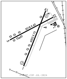
RWY 01–19: H6002X75 (ASPH) S–12.5 MIRL 1.1% up S
RWY 01: PAPI(P2L)–GA 3.5° TCH 40′. P–line.
RWY 19: PAPI(P2L)–GA 3.0° TCH 40′. Fence.
RWY 05–23: H5018X60 (ASPH) S–12.5 MIRL 1.2% up SW
RWY 05: Fence.
RWY 23: Road.
SERVICE: S4 FUEL 100LL, JET A, A1+ LGT MIRL Rwy 01–19 preset low intst; to incr intst and to ACTVT MIRL Rwy 05–23–CTAF. PAPI Rwy 01 does not prvd obstn clnc byd 2 NM fm thr.
AIRPORTREMARKS:Attended Mon–Fri 1400–2300Z‡, Sat 1400–2200Z‡. Unattended Sun and major hols. Aft hrs call–in fee. Self svc fuel avbl 24 hrs.
AIRPORT MANAGER: 432-837-5929
WEATHER DATA SOURCES: AWOS–3 119.025 (432) 837–9613.
COMMUNICATIONS: CTAF/UNICOM 122.8
®ALBUQUERQUE CENTER APP/DEP CON 135.875
CLEARANCE DELIVERY PHONE: For CD ctc Albuquerque ARTCC at 505-856-4861.
RADIO AIDS TO NAVIGATION: NOTAM FILE FST.
FORT STOCKTON (VH) (H) VORTACW 116.9 FST Chan 116 N30°57.13′ W102°58.54′ 216° 50.0 NM to fld. 2893/11E.
VOR unusable:
020°–055° byd 20 NM blo 6,900′
070°–086° byd 35 NM blo 6,400′
106°–132° byd 30 NM blo 5,900′
125°–202° byd 40 NM
203°–213° byd 40 NM blo 18,000′
214°–230° byd 40 NM
245°–255° byd 40 NM
315°–330° byd 30 NM blo 5,400′