SOUTH LAKE TAHOE
LAKE TAHOE (TVL)(KTVL) 3 SW UTC–8(–7DT) N38°53.63′ W119°59.72′ 6268 B TPA–See Remarks NOTAM FILE TVL
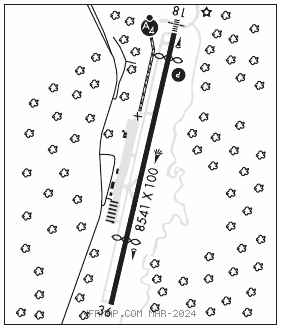
RWY 18–36: H8541X100 (ASPH–GRVD) S–70, D–125, 2S–159, 2D–210 MIRL
RWY 18: MALSF. PAPI(P4L)–GA 3.0° TCH 48′. Thld dsplcd 800′. Brush.
RWY 36: REIL. Thld dsplcd 2033′. Trees. Rgt tfc.
RUNWAY DECLARED DISTANCE INFORMATION
RWY 18: TORA–8541 TODA–8541 ASDA–7817 LDA–7017
RWY 36: TORA–8541 TODA–8541 ASDA–7741 LDA–5708
SERVICE: S2 FUEL 100LL, JET A OX 1, 3 LGT ACTIVATE MALSF Rwy 18; PAPI Rwy 18, MIRL Rwy 18–36–CTAF. Rwy 18 PAPI unusbl byd 2 deg left of rwy cntrln and byd 3 NM.
NOISE: Access noise restrictions: max 80 DBA departure, 84 DBA arrival (Transport–85 DBA), maximum 77.1 DBA night limit. Noise abatement, DEP RWY 36 HDG 1 mile, left 320 DEG to shoreline. For noise abatement info call 530–542–6182.
AIRPORTREMARKS:Attended 1500–0000Z‡. Arpt conditions not monitored 0000–1500Z‡. Arpt conds not mnt Sat–Sun. Birds and waterfowl invof arpt. After winter storms Rwy 18–36 opens before all taxiways are clear. Arpt surrounded on east, south and west by rapidly rising terrain. Tfc advisories and sequencing in the tfc pattern are based on position reports received from pilots in these areas. Adverse weather effects magnified by mountains. Avoid Desolation Wilderness west of arpt. Preferred arrival Rwy 18. Preferred departure Rwy 36. For large and high performance acft dep Rwy 18, right downwind dep is recommended. Recreational airborne activity along southern lakeshore. Paragliders and motorized prchts opr from rwy sfc. Cold temperature airport. Altitude correction required at or below –13C. TPA 7500(1232) small acft, 8000(1732) transport/high performance aircraft. Twy H clsd perm.
AIRPORT MANAGER: 530-542-6182
WEATHER DATA SOURCES: ASOS 124.725 (530) 541–5739. Unrelbl wind spd and dir info. LAWRS.
COMMUNICATIONS: CTAF/UNICOM 122.85
SQUAW VALLEY RCO 122.5 (RENO RADIO)
®OAKLAND CENTER APP/DEP CON 127.95 316.1
CLNC DEL 134.3
AIRSPACE: CLASS E.
RADIO AIDS TO NAVIGATION: NOTAM FILE TVL.
PALISADES (VL) (DH) VORW/DME 113.2 SWR Chan 79 N39°10.82′ W120°16.18′ 127° 21.4 NM to fld. 885016E.
VOR unusable:
036°–048° byd 40 NM
112°–124° byd 40 NM blo 14,000′
112°–124° byd 53 NM
LDA/DME 108.9 I–TVL Chan 26 Rwy 18. LDA/DME Rwy 18 unmonitored. LOC front unusable byd 15° left and 15° right of course. LOC front unusable within 4.0 DME.