STERLING MUNI (STK)(KSTK) 3 W UTC–7(–6DT) N40°36.86′ W103°15.86′
4038 B NOTAM FILE DEN
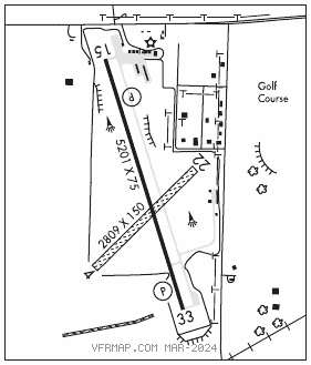
RWY 15–33: H5201X75 (ASPH) S–30 MIRL
RWY 15: REIL. PAPI(P2L)–GA 3.0° TCH 44′. Tree.
RWY 33: REIL. PAPI(P2L)–GA 3.0° TCH 44′.
RWY 04–22: 2809X150 (TURF–GRVL)
RWY 04: Road.
RWY 22: Tree.
SERVICE: FUEL 100LL, JET A LGT When ATCT CLSD ACTVT REIL RWY 15 and RWY 33; MIRL RWY 15–33–CTAF. PAPI RWY 15 and RWY 33 OPR consly. INCR MIRL INTST–CTAF.
AIRPORT REMARKS: Attended 1400–2300Z‡. For after hrs svc call 970–520–2325. Aerobatic OPS on and INVOF ARPT. Be alert; intensive USAF student TRG INVOF KCOS and KPUB airports. RWY 04–22 soft and rough when wet. Varmint holes near Rwy 04 end. Intensive AG OPS MAR–SEPT. RWY 04–22 ends MKD with red/green reflectors. TWY and TRML tiedown area MKD with blue reflectors. RWY 04 DEP has 8 FT fence 155′ FT FM DEP end of RWY. NOTE: See Special Notices–Aerobatic Operations in Colorado.
AIRPORT MANAGER: 970-522-0417
WEATHER DATA SOURCES: AWOS–3 118.525 (970) 526–3009.
COMMUNICATIONS: CTAF/UNICOM 122.8
CLEARANCE DELIVERY PHONE: For CD ctc Denver ARTCC at 303-651-4257.
RADIO AIDS TO NAVIGATION: NOTAM FILE AKO.
AKRON (VH) (H) VORW/DME 114.4 AKO Chan 91 N40°09.33′ W103°10.78′ 339° 27.8 NM to fld. 4623/13E.
VOR unusable:
228°–232° byd 40 NM