PLACERVILLE (PVF)(KPVF) 3 E UTC–8(–7DT) N38°43.45′ W120°45.20′
2586 B TPA–3386(800) NOTAM FILE RIU
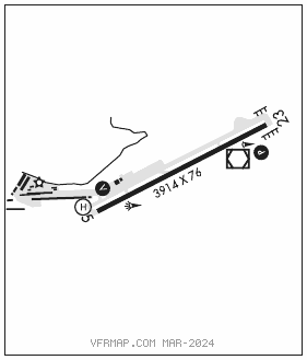
RWY 05–23: H3914X76 (ASPH) S–26 MIRL
RWY 05: VASI(V4L)–GA 3.0° TCH 22′. Rgt tfc.
RWY 23: PAPI(P2L)–GA 3.75° TCH 28′.
SERVICE: S4 FUEL 100LL, JET A LGT ACTVT VASI Rwy 05; PAPI Rwy 23; MIRL Rwy 05–23–CTAF.
NOISE: Noise abatement procedures no mid–field departures, no turns W or N prior to 3400 MSL or clear of noise sensitive area. Rwy 23 after tkf make 10° left turn at end of rwy to avoid noise sensitive residential areas. Helipad located on N side of Rwy 05 end, tfc pat and noise abatement procedures apply.
AIRPORT REMARKS: Attended 1600–0100Z‡. Fuel avbl 24 hrs by credit card. Deer on and invof rwy especially ngts. PPR for touch and go ldgs for acft over 12,500 pounds. Trees 750′ north Rwy 05–23 2697′ MSL (110′ AGL) not lgtd.
AIRPORT MANAGER: 530-622-0459
WEATHER DATA SOURCES: AWOS–3 128.125 (530) 622–5698.
COMMUNICATIONS: CTAF/UNICOM 122.8
HANGTOWN RCO 122.1R 115.5T (RANCHO MURIETA RADIO)
®NORCAL APP/DEP CON 127.4
CLEARANCE DELIVERY PHONE: For CD ctc NorCal Apch at 916-361-6874.
RADIO AIDS TO NAVIGATION: NOTAM FILE RIU.
HANGTOWN (L) (L) VOR/DME 115.5 HNW Chan 102 N38°43.48′ W120°44.96′ at fld. 2604/17E.
VOR unusable:
200°–260° byd 15 NM blo 9,500′
320°–350° byd 10 NM blo 6,000′
320°–350° byd 25 NM blo 14,500′
• • • • • • • • • • • • • • • • • •
HELIPAD H1: H50X50 (CONC)
HELIPORT REMARKS: Helipad parking at NE end of rwy.