RIO VISTA MUNI (O88) 3 NW UTC–8(–7DT) N38°11.60′ W121°42.22′
23 B NOTAM FILE RIU
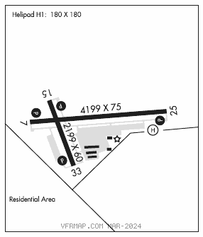
RWY 07–25: H4199X75 (ASPH) S–30 MIRL
RWY 07: REIL. PAPI(P2L)–GA 4.0° TCH 40′.
RWY 25: REIL. PAPI(P2L)–GA 4.0° TCH 40′. Rgt tfc.
RWY 15–33: H2199X60 (ASPH) S–12.5 MIRL
RWY 15: REIL. PAPI(P2L)–GA 4.0° TCH 40′. Pole.
RWY 33: REIL. PAPI(P2L)–GA 4.0° TCH 40′. Rgt tfc.
SERVICE: FUEL 100LL LGT ACTVT REIL Rwy 07, 15, 25 and 33; PAPI Rwy 07, 15, 25 and 33; MIRL Rwy 07–25 and 15–33; Perimeter H1–CTAF.
NOISE: Noise sensitive area N of Rwy 33. Do not overfly ranch and corrals off Rwy 33. All rwys climb to 700′ before turns.
AIRPORTREMARKS:Attended Mon–Thu 1600–0100Z‡. Fast pay fuel system avbl 24 hours. Rwy 25 calm wind rwy.
AIRPORT MANAGER: 707-249-7510
WEATHER DATA SOURCES: AWOS–AV 127.075 (707) 374–5396.
COMMUNICATIONS: CTAF/UNICOM 122.725
®TRAVIS APP/DEP CON 119.9
CLEARANCE DELIVERY PHONE: For CD ctc Oakland ARTCC at 510-745-3380.
RADIO AIDS TO NAVIGATION: NOTAM FILE SAC.
SACRAMENTO (VH) (H) VORTACW 115.2 SAC Chan 99 N38°26.62′ W121°33.10′ 189° 16.6 NM to fld. 3/17E.
VOR unusable:
031°–041° byd 40 NM blo 5,000′
031°–041° byd 45 NM blo 18,000′
157°–169° byd 40 NM blo 4,500′
157°–169° byd 56 NM blo 18,000′
246°–251° byd 40 NM
252°–262° byd 40 NM blo 7,000′
252°–262° byd 65 NM
263°–269° byd 40 NM
353°–013° byd 40 NM blo 5,000′
353°–013° byd 49 NM blo 5,500′
353°–013° byd 58 NM
• • • • • • • • • • • • • • • • • •
HELIPAD H1: H180X180 (CONC) PERIMETER LGTS
HELIPORT REMARKS: No autorotations, hovering auto′s or running landings to pavement. Helicopter tfc to helipad remain S of arpt 500′. When wind favors Rwy 15–33 helicopters may use apron area W of Rwy 15–33, remain W of arpt 500′.