CAMERON PARK (O61) 0 N UTC–8(–7DT) N38°41.04′ W120°59.25′
1287 TPA–2301(1014) NOTAM FILE RIU
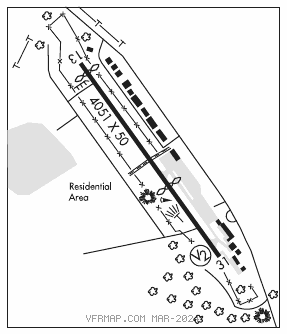
RWY 13–31: H4051X50 (ASPH) MIRL 0.5% up NW
RWY 13: Thld dsplcd 193′. Tree.
RWY 31: PVASI(PSIL)–GA 6.0° TCH 18′. Thld dsplcd 1509′. Tree.
SERVICE: S4 FUEL 100LL LGT ACTIVATE MIRL Rwy 13–31–CTAF.
NOISE: Noise abatement procedures call arpt manager 530–676–8316.
AIRPORTREMARKS:Attended Mon–Fri 1600–0100Z‡. Fuel avbl continuously by credit card. Migratory geese invof arpt. Do not confuse parl residential streets on both sides of arpt with the rwy. Rwy 13–31 restricted to use by acft with less than a maximum certificated gross weight of 12,500 pounds and wingspan less than 50′. Helicopter parking not authorized. 1597′ hill unlgtd 0.5 NM SE of arpt. Rwy 13–31 west side 60′ gates in perimeter fencing to provide access to residential area for residents and invited guests.
AIRPORT MANAGER: 530-676-8316
WEATHER DATA SOURCES: AWOS–1 120.0 (530) 677–5392.
COMMUNICATIONS: CTAF/UNICOM 123.05
CLEARANCE DELIVERY PHONE: For CD ctc NorCal Apch at 916-361-6874.
RADIO AIDS TO NAVIGATION: NOTAM FILE RIU.
HANGTOWN (L) (L) VOR/DME 115.5 HNW Chan 102 N38°43.48′ W120°44.96′ 241° 11.5 NM to fld. 2604/17E.
VOR unusable:
200°–260° byd 15 NM blo 9,500′
320°–350° byd 10 NM blo 6,000′
320°–350° byd 25 NM blo 14,500′