WESTERLY STATE (WST)(KWST) 2 SE UTC–5(–4DT) N41°20.98′ W71°48.21′
81 B NOTAM FILE WST
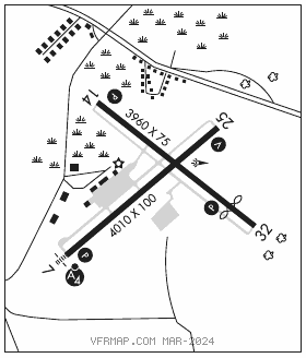
RWY 07–25: H4010X100 (ASPH–GRVD) S–30, D–60 MIRL 0.7% up NE
RWY 07: MALSF. PAPI(P4R)–GA 3.5° TCH 46′. Trees.
RWY 25: REIL. VASI(V2L)–GA 3.5° TCH 36′. Trees.
RWY 14–32: H3960X75 (ASPH) S–12.5 MIRL 0.6% up SE
RWY 14: REIL. PAPI(P4L)–GA 4.0° TCH 40′. Trees.
RWY 32: REIL. PAPI(P4L)–GA 4.0° TCH 40′. Thld dsplcd 750′. Trees.
SERVICE: S4 FUEL 100LL, JET A LGT Dusk–Dawn. ACTVT MALSF Rwy 07; REIL Rwy 25, Rwy 14 and Rwy 32; PAPI Rwy 07, Rwy 14 and Rwy 32; VASI Rwy 25; MIRL Rwy 07–25 and Rwy 14–32–CTAF. Rwy 07 PAPI U/S. Rwy 14 PAPI U/S.
NOISE: Noise abatement procs in efct ctc amgr at 401–691–2265. Arpt lctd in noise sensitive area. Populated areas to the S & W should be avoided.
AIRPORT REMARKS: Attended 1300–2200Z‡ Sun–Sat Jun–Sep, 1300–2100Z‡ Sun–Sat Oct–May. Parachute Jumping. Deer and birds on and invof arpt. Self svc 100LL avbl 24 hrs. Gldrs opr fm arpt on intmnt basis. Hel tours & banner tow ops on airfield blw 1000 ft alg southern coast of Rhode Island. For after hrs terminal apron access ctc arpt manager 401–691–2265. Rwy 07–25 is the preferred calm wind rwy. Rwy conds may not be mnt or rprtd when AP is unatndd. Ctc RI AP Corporation Ops 401–691–2265. Rwy 07–25 uneven pavement approximately 1,000′ from AER 25 thld. Ctc arpt manager 401–691–2265. Rwy 07 tempo dthr 375 ft. Rwy 14 tempo dthr 595 ft. Rwy 07–25 nmrs cracks full len. Rwy 14–32 nmrs cracks full len. Overnight parking fee. Ldg fee for commercial and non Rhode Island registered acft.
AIRPORT MANAGER: 401-691-2265
WEATHER DATA SOURCES: ASOS 132.375 (401) 596–9543.
COMMUNICATIONS: CTAF/UNICOM 123.0
®PROVIDENCE APP/DEP CON 119.45 (South of ORW) (Sun–Fri 1030–0530Z‡, Sat 1030–0500Z‡) other times ctc
BOSTON CENTER APP/DEP CON 124.85
CLEARANCE DELIVERY PHONE: For CD ctc Providence Apch at 401-738-8945, when Apch clsd ctc Boston ARTCC at 603-879-6859.
RADIO AIDS TO NAVIGATION: NOTAM FILE GON.
GROTON (T) (T) VORW/DME 110.85 GON Chan 45(Y) N41°19.82′ W72°03.12′ 098° 11.3 NM to fld. 9/14W.
VOR portion unusable:
241°–265° blo 5,000′
DME unusable:
355°–019° blo 3,000′
LOC/DME 108.9 I–RLS Chan 26 Rwy 07. LOC unmonitored.