JACKSONVILLE
CECIL (VQQ)(KVQQ) P (ARNG) 0 N UTC–5(–4DT) N30°13.13′ W81°52.63′ 80 B NOTAM FILE VQQ
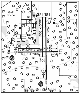
RWY 18L–36R: H12503X200 (ASPH–CONC) PCN 59 R/B/W/T HIRL
RWY 18L: REIL. PAPI(P4L)–GA 3.0° TCH 66′. Trees.
RWY 36R: MALSR. PAPI(P4L)–GA 3.0° TCH 66′. Trees.
RWY 09R–27L: H8003X200 (ASPH–CONC) PCN 21 F/A/X/T HIRL
RWY 09R: MALSR. PAPI(P4L)–GA 3.0° TCH 68′. Trees.
RWY 27L: REIL. PAPI(P4L)–GA 3.0° TCH 67′. Trees.
RWY 18R–36L: H8002X200 (ASPH–CONC) PCN 21 F/A/Y/T
RWY 18R: Trees.
RWY 09L–27R: H4439X200 (ASPH–CONC) PCN 27 R/B/X/T
RWY 09L: Trees.
SERVICE: S4 FUEL 100LL, JET A1+ OX 1, 3, 4 LGT When ATCT clsd actvt MALSR Rwy 09R and 36R; REIL Rwy 18L and Rwy 27L; HIRL Rwy 18L–36R, Rwy 09R–27L–CTAF. MILITARY–FUEL A+ (Avbl H24 Mon–Fri, 1100–0400Z‡ Sat and Sun, and hol C904–317–6550. 130.925. OT 12 hr PN rqr and $60 fee per occurence.) (NC–100LL, A).
AIRPORT REMARKS: Attended Mon–Fri 1200–0400Z‡, Sat–Sun 1200–0200Z‡. Wildlife invof arpt. VTOL ops not auth. Dalgt gldr ops 6000 ft & blw; Herlong Recreational 5 NM NE. 180° turn on asph ptns of rwy by P–3 or larger na. Mil carrier break na. Hold shrt sign Rwy 09L–27R & Rwy 18R–36L unlgtd. Rwy 09L–27R rstd to fixed wing acft 12,500 lbs and blw. Rwy 18R–36L rstd to acft with wingspan of less than 79 ft, excluding txy xng. Twy C clsd at mil gate. Twy M clsd exec to mil acft. Dep turns prior to DER wo twr apvl na. Air to FBO com–130.925. Rwy 18R–36L longl and transverse cracking btn ints.
AIRPORT MANAGER: 904-573-1601
WEATHER DATA SOURCES: AWOS–3 125.275 (904) 778–6934.
COMMUNICATIONS: CTAF 126.1 ATIS 125.275
®JACKSONVILLE APP/DEP CON 127.775
TOWER 126.1 (1200–0400Z‡ Mon–Fri, 1200–0200Z‡ Sat–Sun) GND CON 121.625
CLNC DEL 123.975
GCO 135.075 (JACKSONVILLE APCH)
CLEARANCE DELIVERY PHONE: For CD when ATCT clsd, and una via GCO, ctc Jacksonville tracon at 904-741-0284.
AIRSPACE: CLASS D svc 1200–0400Z‡ Mon–Fri, 1200–0200Z‡ Sat–Sun; other times CLASS G.
RADIO AIDS TO NAVIGATION: NOTAM FILE CRG.
CRAIG (H) (H) VORTACW 114.5 CRG Chan 92 N30°20.33′ W81°30.60′ 252° 20.4 NM to fld. 42/3W.
ILS/DME 109.5 I–VQQ Chan 32 Rwy 36R. Class IE. Unmonitored when ATCT clsd. DME unusable byd 28° right of course.
COMM/NAV/WEATHER REMARKS: Air to FBO com 130.925.
• • • • • • • • • • • • • • • • • •
HELIPAD H1: H70X70 (CONC)
HELIPAD H2: H70X70 (CONC)