VAN NUYS (VNY)(KVNY) P (ANG) 3 NW UTC–8(–7DT) N34°12.59′ W118°29.40′
802 B TPA–See Remarks NOTAM FILE VNY MON Airport
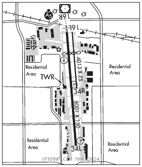
RWY 16R–34L: H8001X150 (ASPH) S–90, D–120, 2S–152, 2D–210 HIRL
RWY 16R: MALSR. PAPI(P4R)–GA 3.5° TCH 49′. RVR–T Thld dsplcd 1432′. Fence. Rgt tfc. 0.7% down.
RWY 34L: PAPI(P4R)–GA 3.0° TCH 54′. Trees. 0.7% up.
RWY 16L–34R: H4013X75 (ASPH) S–14 MIRL 0.7% up N
RWY 16L: Thld dsplcd 1434′. Railroad.
RWY 34R: PAPI(P4L)–GA 3.0° TCH 30′. Rgt tfc.
RUNWAY DECLARED DISTANCE INFORMATION
RWY 16L:TORA–4013 TODA–4013 ASDA–4013 LDA–2582
RWY 16R:TORA–8001 TODA–8001 ASDA–8001 LDA–6570
RWY 34L:TORA–8001 TODA–8001 ASDA–7261 LDA–7261
RWY 34R:TORA–4013 TODA–4013 ASDA–3906 LDA–3906
SERVICE: S4 FUEL 100LL, JET A OX 1, 3 LGT When ATCT clsd ACTIVATE MALSR Rwy 16R ; HIRL Rwy 16R–34L; twy lgts–CTAF. A2 and A3 have unidirectional centerline lgt. Rwy 16R VGSI unusbl byd 6 NM due to trrn. MILITARY– FUEL A+ (C818–989–2300.) (NC–100LL, A) FLUID OX.
NOISE: Extreme noise sensitive area. Noise Ordinance Curfew: No tkf for acft exceeding 74 DBA (PER AC36–3) between 0600–1500Z‡, except military, mercy flights and law enforcement acft. Rwy 16L and Rwy 16R no turns before the flood basin, unless directed by twr. Rwy 34L and Rwy 34R no turns before reaching 1800′ MSL unless directed by twr. No acft may arrive or depart the arpt whose AC36–3 tkof noise level equals or exceeds 77 DBA. Jets: Avoid dep and arr btn 11 pm and 7 am to rdc noise over community. Turbine/jet aircraft operators are requested to use NBAA noise abatement program procedures or comparable procedures of aircraft manufacturer.
AIRPORT REMARKS: Attended continuously. Arpt CLOSED to air carrier ops. Birds on and invof arpt. Bird abatement may occur between rwys when twr is open. When twr clsd, acft must self announce on freq 119.3 prior to ldg or departing. Rwy 16R left tfc when ATCT clsd. Rwy 16L–34R CLOSED and unlgtd when twr clsd. Helicopter ctc twr for apch–dep routes. TPA–2002(1200) Rwy 16R–34L, 1802(1000) Rwy 16L–34R. All jet acft must use full rwy length for departure unless otherwise directed by twr. Formation arrivals and departures prohibited except for emerg response acft. Txl A1 WB taxi only. Taxilane A3 westbound taxi only. Taxilane A2 eastbound taxi only. Taxilane A2/A3 have undirectional centerline lgts. Twy A south of Twy P acft with wingspan over 100 ft encroach on Rwy 16R–34L rsa. Twy B south of Twy Q acft with wingspan over 100 ft encroach on Rwy 16R–34L rsa. Txl A1, A2 and A3 are ATCT nonvisible areas. All pilots are reqstd to ctc ATCT at checkpoint 1 on Txl A2 when tax out from the NW airfield. NOTE: See Special Notices–Arrival Alert.
AIRPORT MANAGER: 818-442-6500
WEATHER DATA SOURCES: ASOS (818) 904–9213 LAWRS.
COMMUNICATIONS: CTAF 119.3 ATIS 127.55 818–780–4993 UNICOM 122.95
®SOCAL APP/DEP CON 124.6 (South btn BUR 150°–VNY 160°), 134.2 (160°–280° VNY, West), 120.4 (VNY 280°–BUR 050°, North), 135.05 (050°–150° BUR)
TOWER 119.3 (162°–345° and dep Rwy 16R–34L), 120.2 (346°–161° and dep Rwy 16L–34R), 119.0 (helicopters)(1400–0645Z‡) GND CON 121.7
CLNC DEL 126.6
CPDLC (LOGON KUSA)
PDC
CLEARANCE DELIVERY PHONE: For CD when ATCT clsd ctc SoCal Apch at 800-448-3724.
AIRSPACE: CLASS D svc 1400–0645Z‡; other times CLASS E.
RADIO AIDS TO NAVIGATION: NOTAM FILE VNY.
(VL) (L) VORW/DME 113.1 VNY Chan 78 N34°13.41′ W118°29.50′ at fld. 812/15E.
VOR unusable:
103°–108° byd 35 NM
118°–226° byd 25 NM
305°–055° byd 19 NM
DME unusable:
055°–078° byd 23 NM
103°–108° byd 30 NM
118°–299° byd 20 NM
300°–315° byd 15 NM
316°–054° byd 19 NM
ILS 111.3 I–VNY Rwy 16R. Class IA. Unmonitored when ATCT closed. LOC unusable within 0.6 NM.