QUILLAYUTE (UIL)(KUIL) 7 E UTC–8(–7DT) N47°56.19′ W124°33.76′
194 NOTAM FILE UIL
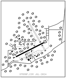
RWY 04–22: H4211X100 (CONC) S–30, D–50 0.4% up NE
RWY 04: Trees.
AIRPORTREMARKS:Unattended. Pedestrians, veh and animals on and invof rwy.
AIRPORT MANAGER: 360-374-5412
WEATHER DATA SOURCES: ASOS 135.225 (360) 374–9731.
COMMUNICATIONS: CTAF 122.9
CLEARANCE DELIVERY PHONE: For CD ctc Seattle ARTCC at 253-351-3694.
RADIO AIDS TO NAVIGATION: NOTAM FILE SEA.
TATOOSH (VH) (H) VORTACW 112.2 TOU Chan 59 N48°17.99′ W124°37.62′ 151° 22.0 NM to fld. 1650/22E.
VOR unusable:
020°–025° byd 40 NM
085°–090° byd 40 NM
091°–101° byd 40 NM blo 15,000′
091°–101° byd 58 NM
103°–109° byd 40 NM
356°–360° byd 40 NM