AURORA STATE (UAO)(KUAO) 1 NW UTC–8(–7DT) N45°14.83′ W122°46.20′
200 B NOTAM FILE UAO MON Airport
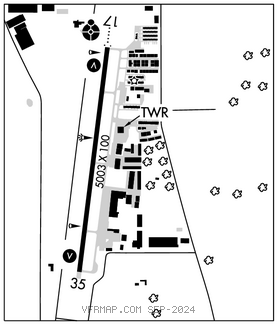
RWY 17–35: H5003X100 (ASPH–GRVD) S–30, D–45 MIRL
RWY 17: ODALS. VASI(V4R)–GA 3.5° TCH 38′. Trees.
RWY 35: VASI(V4L)–GA 3.25° TCH 51′. Tree.
SERVICE: S4 FUEL 100LL, JET A OX 1 LGT ACTIVATE MIRL Rwy 17–35, VASI Rwy 17 and Rwy 35 and ODALS Rwy 17–CTAF. Parallel twy 35′ wide and has medium ints twy lgts.
NOISE: Noise abatement proc in efct, ctc ops for noise rules 503–931–4298. Noise abatement sensitive area: 2 miles N of Rwy 17; 1 mile SE of Rwy 35; half mile SW of Rwy 35. Avoid low level over–flights of residential areas surrounding arpt whenever possible.
AIRPORTREMARKS:Attended 1500–0400Z‡. Migratory birds, coyotes, and deer on and invof arpt. Rwy 17 +30′ p–line 2100′ from thld, marked by balls. Rwy 17–35 has 150′ blast pad at south end. Rwy 35 calm wind rwy. Use only paved sfcs. Frequent straight–in instrument apch tfc to Rwy 17. Overweight acft ctc owner prior 503–378–4880. All taxilanes non std wingtip clnc.
AIRPORT MANAGER: 503-378-4880
WEATHER DATA SOURCES: ASOS 118.525 (503) 678–3011. LAWRS.
COMMUNICATIONS: CTAF 120.35 ATIS 118.525 (1500–0400Z‡) 503–678–3011
®PORTLAND APP/DEP CON 126.0 269.175 (LOW) 118.1 284.6 (HIGH)
AURORA TOWER 120.35 (1500–0400Z‡) GND CON 119.15 CLNC DEL 119.15 119.95 (when UAO twr clsd)
AIRSPACE: CLASS D svc 1500–0400Z‡; other times CLASS E.
RADIO AIDS TO NAVIGATION: NOTAM FILE MMV.
NEWBERG (VH) (DH) VORW/DME 117.4 UBG Chan 121 N45°21.19′ W122°58.69′ 105° 10.9 NM to fld. 1443/21E.
VOR unusable:
095°–105° byd 40 NM
106°–120° byd 40 NM blo 7,800′
106°–120° byd 60 NM
135°–328° byd 40 NM
329°–346° byd 40 NM blo 5,000′
329°–346° byd 70 NM
347°–080° byd 40 NM
LOC/DME 111.15 I–UAO Chan 48(Y) Rwy 17. Class IA. DME unusable beyond 15.2 NM blo 2,500′.