MID VALLEY (TXW)(KTXW) 1 NE UTC–6(–5DT) N26°10.72′ W97°58.44′
70 B LRA NOTAM FILE TXW
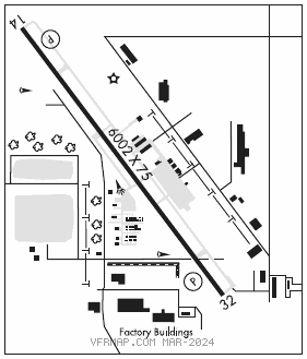
RWY 14–32: H6002X75 (ASPH) S–12.5 MIRL
RWY 14: PAPI(P4L)—GA 3.0° TCH 50′. Trees.
RWY 32: REIL. PAPI(P4L)—GA 3.18° TCH 51′. Pole. Rgt tfc.
SERVICE: S4 FUEL 100LL, JET A LGT MIRL Rwy 14–32 preset low intst; to incr intst and actvt REIL Rwy 32—CTAF.
AIRPORT REMARKS: Attended Mon–Sat 1300–0000Z‡. For atndnt aft hrs, call 956–469–0291 durg atndd hrs. Fuel avbl 24 hrs self–serve. 30′ pole 315′ northeast of helipad.
AIRPORT MANAGER: 956-969-0291
WEATHER DATA SOURCES: AWOS–3PT 118.575 (956) 447–0414.
COMMUNICATIONS: CTAF/UNICOM 122.8
®CORPUS APP/DEP CON 122.65 CLNC DEL 125.95
RADIO AIDS TO NAVIGATION: NOTAM FILE HRL.
HARLINGEN (L) (L) VORW/DME 113.65 HRL Chan 83(Y) N26°13.75′ W97°39.14′ 255° 17.6 NM to fld. 32/5E.